Vancouver Island’s Wild West Coast
- Share via
One of North America’s largest islands, 280-mile-long, 80-mile-wide Vancouver, offers a Holland-size haven for hikers. A mountainous backbone, a mellow east coast and majestic west coast, a rain forest, dramatic fiords, Pacific Rim National Park and dozens of provincial parks are some of the island’s sights.
The largest city, Victoria, is still a bit of Olde England, quaint and oh-so-charming for a carriage ride past the Parliament building or a stop for a spot of tea at the Empress Hotel. However, if you’d rather step into the great outdoors, memorable hiking, cycling and kayaking environments make the area a recreational playground.
Yet with the notable exception of the West Coast Trail, the island’s outdoor attractions remain largely a locals-only pursuit. Hikers in the know copy the resident ramblers and look beyond the tearooms of downtown Victoria to the southern isle’s two dozen coastal parks and hundreds of miles of trails.
“When you combine wild beaches, dramatic bluffs, a rain forest and a superb coastal trails network, you have a hiker’s paradise,” notes Glenn Milbury, owner of Coastal Connections, a Victoria-based company that offers guided kayaking and hiking trips. “Also, Victoria and vicinity has the best weather in Canada.”
In Milbury’s view, the just-completed Juan de Fuca Marine Trail is destined for greatness. “Parts of the trail are as stunning as the world-famous West Coast Trail,” says Milbury, who leads tide-pool explorations at Botanical Beach, the marine trail’s northern trail head. “Plus, visitors can day-hike the Juan de Fuca; you really have to mount a serious backpacking expedition to do the West Coast Trail.”
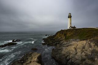
Juan de Fuca Marine Trail, a two-hour or so drive north from Victoria, begins just south of the West Coast Trail. The Juan de Fuca Trail, which traces the Pacific shore of the Strait of Juan de Fuca, offers a superb sampling of Vancouver Island’s rugged beauty, including forested cliffs, meandering creeks and tide pools.
Although the strait was not the shortcut to Asia hoped for by early explorers, it did become a significant sea lane. Hardly a peaceful passageway, the strait’s tides and intemperate weather have wrecked hundreds of ships, earning it the nasty nickname of “The Graveyard of the Pacific.” Today, even with the most modern navigational aides, negotiating the frequently fog-bound strait can be difficult.
The Strait of Juan de Fuca separates two large continents and links North America by a sea lane to the peoples and flourishing economies of the Pacific Rim. More than 1,000 vessels a month carrying cargo to and from the Pacific Rim pass through the strait. In come Toyota automobiles, out go Douglas fir logs through the ports of Seattle, Tacoma and Vancouver.
In addition to lots of ships, hikers may spot gray whales migrating between their Bering Sea feeding waters and their Baja California calving grounds. Resident orcas pursue salmon through the strait.
BC Parks is the steward of the trail. The first half of the path from Botanical Beach to Sombrio Beach was completed during the summer of ‘95; the finishing touches will be put on the second half this summer.
For a moderate day hike of about four hours, hike down-coast from the rich tide pools of Botanical Beach to Parkinson Creek. If you can arrange a car shuttle, the 13.6-mile one-way distance between Botanical Beach to Sombrio Beach is one of North America’s most engaging coastal hikes.
(BEGIN TEXT OF INFOBOX / INFOGRAPHIC)
Juan de Fuca Marine Trail
WHERE: West coast of island
DISTANCE: 30 miles one way (when fully completed).
TERRAIN: Wilderness beach, forested cliffs
HIGHLIGHTS: New trail, superb tide pools.
DEGREE OF DIFFICULTY: Moderate-strenuous
FOR MORE INFORMATION: BC Parks, South Vancouver Island District, 2930 Trans Canada Highway, Victoria, B.C. V9B 5T9 or tel. (250) 391-2300; Coastal Connections, P.O. Box 8360, Victoria B.C., VOW 3R9, Canada, tel. (800) 840-HIKE
More to Read
Sign up for The Wild
We’ll help you find the best places to hike, bike and run, as well as the perfect silent spots for meditation and yoga.
You may occasionally receive promotional content from the Los Angeles Times.


