Winds top a stunning 96 mph in Kincade fire zone, causing havoc across Sonoma County
- Share via
SANTA ROSA, Calif. — Forecasters predicted historic winds.
They didn’t exaggerate.
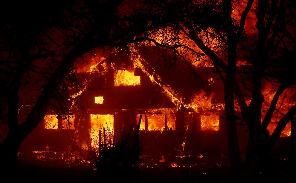
Northern California was battered Sunday by extreme Diablo winds. The National Weather Service clocked a gust of 96 mph in the Mayacamas Mountains northeast of Healdsburg, which is threatened by the 54,000-acre Kincade fire that has destroyed 94 structures. The winds caused the fire that began in northern Sonoma County to explode overnight and move swiftly through the day Sunday, prompting evacuations in Santa Rosa, west to Bodega Bay and southeast to Calistoga in Napa County.
The Diablo winds swept into Santa Rosa early Sunday. The whistles and flutters that announced their coming just past midnight quickly turned into long, angry howls and gusts that rattled buildings.
By 4 a.m., new evacuation orders and warnings came out for more of Santa Rosa, leaving large swaths of the city under threat. By Sunday, not only were the flood-prone town of Guerneville and the Charles M. Schulz Sonoma County Airport ordered evacuated, but so was the Coffey Park neighborhood where hundreds of homes burned in the Tubbs fire in 2017.
A Sutter Health hospital nearby was evacuated Saturday night; it was Kaiser’s turn Sunday, and ambulances snaked the lot loading patients.
A peak wind gust of 96 mph was recorded at Pine Flat in the Mayacamas Mountains about 12 miles northeast of Healdsburg. Sensors also recorded a peak gust of 85 mph just 10 miles to the southeast at Mt. St. Helena, the highest peak in Sonoma County, with an elevation of about 4,300 feet. Both were recorded around 7:50 a.m., said National Weather Service meteorologist Steve Anderson.
“The current wind speeds are pretty much on track as forecast,” Anderson said. “We’re still seeing wind gusts in the 70 mph range,” which were expected to continue into Monday morning. “It’s going to be a long day and night for a lot of people.”
This Diablo wind event, which began Saturday evening, was said to be potentially historic and extreme for Northern California because of its extraordinary 36-hour duration and expected isolated gusts of 65 to 80 mph. It was expected to continue through Monday morning, at a time when vegetation is at its driest and autumn rains have not begun to arrive.
The three most destructive wildfires in modern California history — the Oakland-Berkeley hills fire in 1991, the Tubbs fire in wine country in 2017 and the Camp fire that destroyed the town of Paradise last year — all were spread by downslope wind events that did not persist as long as this one is forecast to.
By Sunday night, Mt. St. Helena was still seeing gusts of around 60 mph, said weather service meteorologist Rick Canepa. Isolated gusts in the lower elevations of the North Bay mountains and East Bay hills were expected to be around 40 to 45 mph through Monday morning.
A new downslope wind event is forecast to begin Tuesday night into Wednesday, with wind gusts expected in the range of 50 mph. “Not close to what we’re seeing now, but definitely extreme fire behavior will go on with those winds,” Anderson said.
In addition, the air has been dry — relative humidity levels have fallen as low as 13% to 15% across the Bay Area, Anderson said.
The amount of water vapor in the air was as low as it gets in the Bay Area for an October day. “It’s rock-bottom dryness, for sure,” Canepa said. “It’s essentially desert air that’s been brought all across Northern California.”
Temperatures had fallen from midweek levels, which reached the 90s when the Kincade fire began to burn out of control on the northern edge of Sonoma County, destroying dozens of structures. In the North Bay, highs topped out in the 70s on Sunday. But the falling temperatures offered little help against the fire’s march; the hot weather last week dried out vegetation even more.
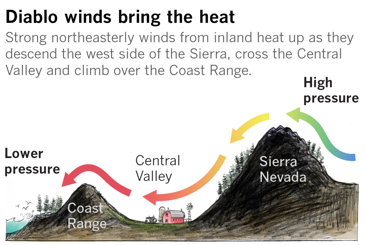
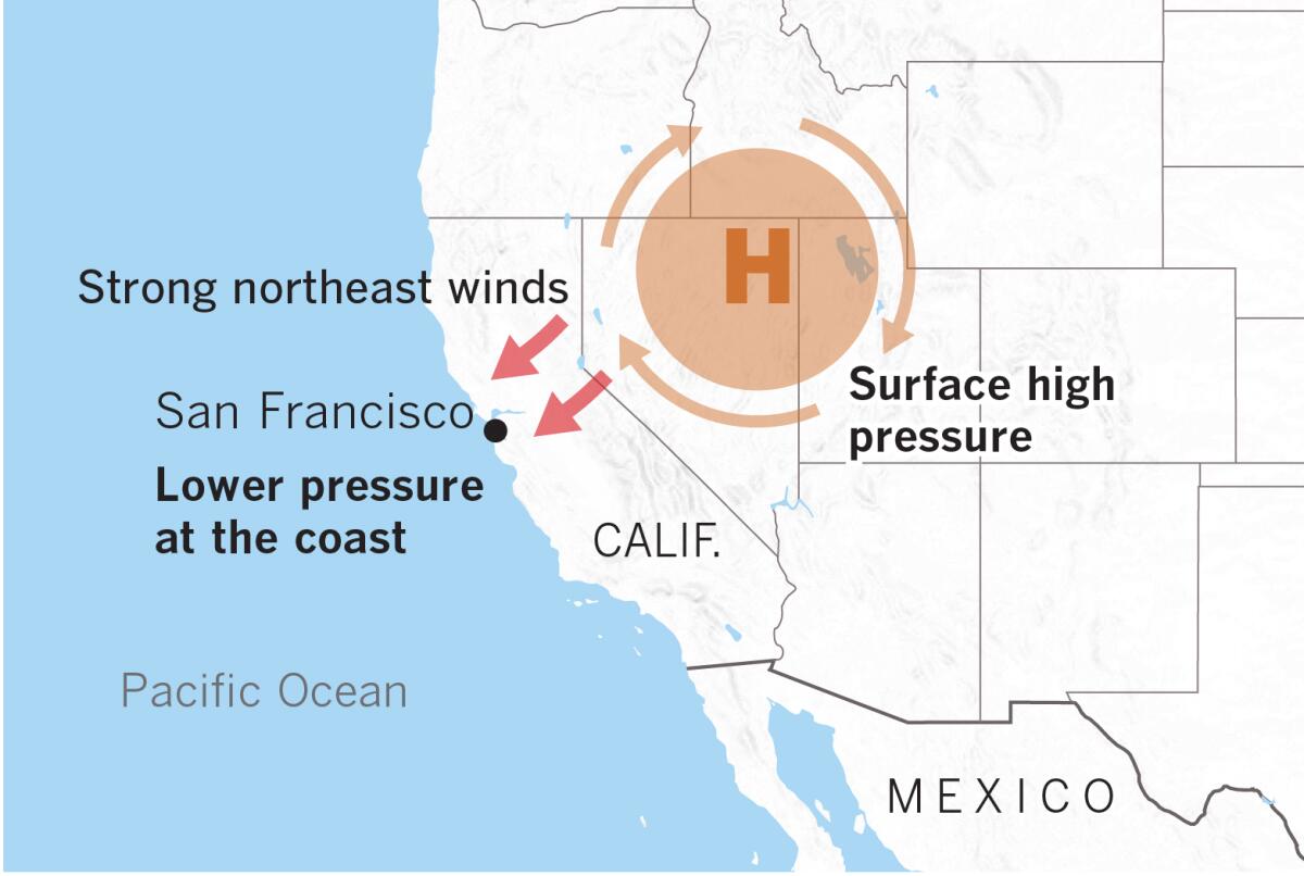
The Diablo winds in Northern California are meteorologically identical to the Santa Ana winds of Southern California. Both come from the northeast and are fueled by high-pressure air over Nevada and Utah seeking a path through the Sierra Nevada and Coast Ranges or Transverse Ranges to fill lower-pressure voids on the coast.
Pacific Gas & Electric Co. says a third round of mass blackouts could be ordered across Northern California in anticipation of the next Diablo wind event.
The short gap between the end of the weekend wind event Monday morning and the next one forecast to begin Tuesday night means some people may not see their power restored before the next “public safety power shut-off” begins.
“Ensure you are prepared that your power may not come back” before the next preventive outage, said Andrew Vesey, president and chief executive of Pacific Gas & Electric Co.
The utility said 32 California counties could be affected across the San Francisco Bay Area, the North Bay, North Coast, Kern County and the northern and southern Sierra.
Company officials say the parts of the North Bay blacked out in this weekend’s planned power outage will probably lose power again during the midweek Diablo wind event. The East Bay and South Bay might see fewer neighborhoods lose power.
In Southern California, a Santa Ana wind event began Sunday night and was expected to last through Monday with isolated gusts of up to 60 mph in the Los Angeles County mountains and humidity levels as low as 5%, causing officials to issue red-flag warnings.
A second Santa Ana event is likely to occur Wednesday and Thursday, with peak wind gusts of 50 mph to 70 mph.
Chabria reported from Santa Rosa, Lin from San Francisco.
More to Read
Sign up for Essential California
The most important California stories and recommendations in your inbox every morning.
You may occasionally receive promotional content from the Los Angeles Times.
