Trump’s been talking about a border wall. Here’s what it’s like to live with one

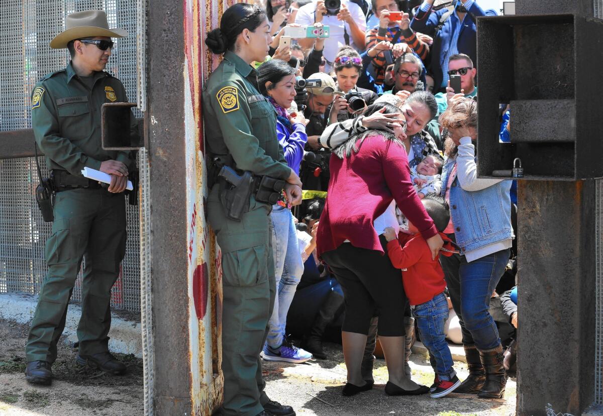
Border Patrol agents watch as members of selected families that have been separated for years reunite — however briefly — at the Door of Hope at Border Field State Park near San Diego. This is the third year for Children’s Day.
- Share via
Reporting from SAN DIEGO — Saturday brought Perla Martinez three minutes of joy, a temporary pause in a long, painful separation.
“It’s really emotional,” said Martinez, a Denver resident, wiping away tears while standing on the U.S. side of the fence separating San Diego and Tijuana. From about 12:20 to 12:23 p.m., she had stood in an open gate at the border to embrace her parents, Mexican citizens Maria Granadoz and Salvador Martinez Hernandez.
She also introduced them to a 3 1/2-year-old granddaughter.
“It’s been 16 years since we were all together,” Martinez said of her family. “This is the first time my parents have seen Samantha.”
Border walls are making headlines, with all three remaining Republican presidential candidates — Donald J. Trump, Sen. Ted Cruz and Ohio Gov. John Kasich — proposing to expand the existing network of barriers between the U.S. and Mexico. Trump has even pledged a “beautiful” wall spanning the entire 1,952-mile boundary, at no cost to U.S. taxpayers.
“I’m gonna say, ‘Mexico, this is not going to continue, you’re going to pay for that wall,’ and they will pay for the wall,” Trump said last summer.
To a significant degree, though, California and Baja California already live with a wall. Since 1989, the United States has erected more than 650 miles of border fences, and the first pilings were sunk near the site of Children’s Day events Saturday.
Once a year, the U.S. Border Patrol swings open an emergency door in that fence. A few selected and screened families — on Saturday, there were five — are allowed to reunite. Parents embrace children. Sisters weep on each other’s shoulders. Grandparents whisper in toddlers’ ears.
See more of our top stories on Facebook >>
“Some believe in building walls,” said Enrique Morones, executive director and founder of Border Angels, the nonprofit that organizes the annual event. “We believe in opening doors.”
This door, though, was open for only about 21 minutes. By 12:31 p.m., it was closed and locked again.
The emotional scenes unfolded on a rise overlooking the sea, the western end of the 137-mile border between California and Mexico. On a map, this boundary is a single unbroken line, traveling northeast from the Pacific Ocean to the Colorado River. This border looks orderly, straight as an arrow.
Or so it appears on paper. Trying to mark the same line on land, the border fence looks like a dragon’s tail. Emerging from the waves, it undulates across ridges, slides down ravines, climbs up cliffs, slithers over mountains in a series of S-shaped switchbacks.
Like life along the border itself, the fence is anything but orderly or straight.
How you see this barrier often depends on where you stand.
In the east San Diego County community of Boulevard, Donna Tisdale notes that carloads of immigrants and drug dealers — up to 100 at a time — once raced across her property. No longer.
“We still have people come through our ranch,” she said, “but it’s in much smaller groups.”
In his native Tecate, Sergio Martinez remembers the day he saw construction teams installing posts on Tecate Peak.
“It felt like an invasion,” he said.
This land of contradictions — of sycamore-shaded valleys and boulder-strewn mountains, sprawling metropolitan areas and vast empty tracts, nature preserves and garbage dumps, grand estates and plywood hovels — resists easy solutions.
“Unless you have lived at the border and have seen what is happening,” Tisdale said, “I think people have a somewhat myopic view of what is actually going on and what would actually help.
“Human nature is the main instigator here. People are going to flee oppression and poverty and attempt to achieve a better life for their family. Until those dynamics change, the immigration issue will continue.”
No barriers
For decades, the U.S.-Mexican border was marked by 52 obelisks placed in the 19th century by commissioners from both nations. Crossings, northbound and southbound, were common and unimpeded.
Yet mystique, even danger, surrounded this territory.
In 1911, a revolutionary band led by Ricardo and Enrique Magón captured Mexicali, then marched west to a settlement of about 700 people, Tijuana. On May 9, under banners proclaiming “Tierra y Libertad” — “Land and Liberty” — the rebels routed the Mexican army and seized control of the town.
NEWSLETTER: Get essential California headlines delivered daily >>
Reporting on the Magónistas’ approach, the San Diego Union had forecast a battle. Hundreds of San Diegans took notice and streamed south for the spectacle.
“The roads were bad then, but people could take a train or a buckboard and go down and actually watch the battle,” said Lawrence Taylor, a history professor at Tijuana’s Colegio de la Frontera Norte. “From the hills of the Otay area, you would have a view of the Tijuana River valley and into the town.”
Despite early victories, the revolt was soon crushed. In the 1920s, though, Prohibition led Washington to tighten border controls. By banning booze north of the border, the law inspired alcohol-fueled tourism to the south — and the illicit cross-border activities of bootleggers and rumrunners.
“You start to see more military, and more law enforcement, on the border in the 1920s and 1930s,” said Matthew Schiff, marketing and projects director at the San Diego History Center.
A photo from this period, displayed in the center’s current border exhibit, shows a single uniformed American holding a clipboard, awaiting northbound traffic. This lone figure would soon have reinforcements. The tiny station grew, as did the traffic.
By 1954, motorists trying to enter the U.S. from Tijuana were subject to long waits to pass through security checkpoints.
Off the main roads, though, there were no barriers. When Sergio Martinez grew up in Tecate, the line was marked by nothing more than a cable.
“We used to go up there,” he pointed to an open field across the border fence, “to play soccer.”
A boon to young athletes, friendly neighbors, peaceful nomads and roaming wildlife, the open border was also ideal for smugglers of migrants, drugs and other contraband. In 1986, Border Patrol apprehensions peaked at 629,656 people, 1 1/2 times the population of Oakland.
When authorities tried to stem this tide in San Diego, migrants moved east into more rugged and less patrolled territory.
“We would have caravans of cars,” Tisdale said of the human tide that rolled across her family’s ranch. “They came at all hours of the day and night.”
The Tisdales’ complaints were ignored — “We were actually called liars” — until TV news crews videotaped the scene.
In 1989, construction began on 46 miles of border fence in San Diego County. This primary fence is more than 10 feet tall and made of military surplus helicopter landing mats. In 1996, secondary fencing, about 15 feet tall, was added to 13 miles. A third layer of fencing later augmented some heavily trafficked areas, such as western Tijuana.
Last year, the Border Patrol apprehended 26,290 people — a 96% decrease from 30 years ago.
Tisdale has noted dwindling numbers of strangers crossing her land. But rather than build more walls, she thinks a more effective solution to the nation’s immigration woes would be to deny benefits to people who cannot prove legal residency.
“If you build a 10-foot wall,” she said, “they are going to build a 12-foot ladder to go over it.”
Sacred mountain
Last year, about 61,000 people entered an uninhabited area about a mile from the international boundary. Many hiked to the border fence in silence, scanning the horizon with binoculars for migrants — or, rather, migratory birds.
Border Field State Park, the largest intact wetlands in Southern California, is a haven for hawks, butterflies, lizards, wildflowers and endangered species, including the California least tern. On most days getting to the picnic areas and restrooms requires a mile trek on foot, as winter rains have closed the road.

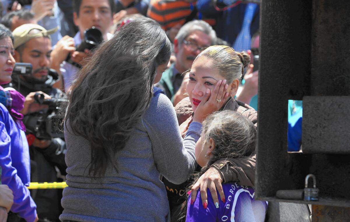
Isela Michel Zavala wipes a tear from her mother, Yudridia Guadalupe Zavala, whose arm is draped over Isela’s daughter Briana Montes, as they meet at the Door of Hope at Border Field State Park.
Although this refuge was established by the state, nature has established its own reserves along the international boundary. Vast stretches of the border fences are miles from public roads, which veer around the hills, mountains and boulder-strewn chasms that mark the meeting of California and Baja California.
Canyons are dotted with yucca, sycamores and a few stands of California oak. Rolling hillsides are yellow with straw, the occasional splash of color supplied by lupin, Indian paintbrush and mustard grass.
Off California Highway 94, east of Jamul, a dirt road leads past a gun club and into a series of steep hills, rising one after another, like a series of monstrous waves. Get out of your car for a hike and you may see .45 shell casings at your feet or a gopher snake soaking up the sun.
Further east, Highway 94 intersects Highway 188, the road to Tecate. A few hundred people live on the hilly California side, including a divorced 80-year-old former heavy equipment operator who has eked out a frugal existence here for a quarter-century.
Unwilling to give his name — “I don’t want to be singled out” — he was eager to give his opinion. Physical barriers on the border aren’t needed, he said, thanks to surveillance by drones and electronic sensors.
“A rat couldn’t even get through it,” he said, “without them seeing it.”
In fact, the physical fence stops halfway up the imposing peak the local Kumeyaay regard as a sacred mountain, Kuchamaa, or Mt. Tecate. For miles, this terrain is so forbidding that unnatural barriers are deemed redundant.
Tecate may be best known for its eponymous beer, but this town of roughly 70,000 is also a testament to close binational ties. In 1940, newlyweds Edmond and Deborah Szekely founded their first spa here, Rancho La Puerta. (A second, the Golden Door, would follow in Escondido.)
Edmond Szekely died in 1979, but he’s still here. The spa’s foundation carved out a natural preserve from a 27-acre plot in the shadow of Kuchamaa. Parque del Profesor is dedicated to Szekely, and his bust dominates a courtyard where children gather for lessons in environmental science.
Natural trails lead past cave-like classrooms linked by tunnels. Although there’s a binational agreement to protect the plants and animals of Kuchamaa, the border fence reminds everyone that the two nations haven’t always worked in harmony.
“Look at how much money they will spend for absolutely nothing,” said Sergio Martinez, who is a director at the park. “How is the coyote going to get back and forth to see his Mexican girlfriend?”
There was a pause, then Martinez laughed as he recalled that “coyote” is also a term used for human smugglers.
“Not that kind of coyote,” he said.
Rowe writes for the San Diego Union-Tribune.
ALSO
Why a historic highway that united California’s two halves may never reopen to cars
Florida Gov. Rick Scott wants to use the minimum wage hike to steal California businesses
Navy warship parade is back on in San Diego
More to Read
Sign up for Essential California
The most important California stories and recommendations in your inbox every morning.
You may occasionally receive promotional content from the Los Angeles Times.


