Seismologists hope to create earthquake forecasts for California, using small temblors to warn of big ones

Earthquakes occur all over the world, mostly around plate edges, on faults. Here are 10 tips to follow to ensure survival. (Sign up for our free video newsletter here http://bit.ly/2n6VKPR)
- Share via
One day, next to the traffic map and weather forecast on your smartphone, seismologist Thomas H. Jordan envisions an app that you can check to see when the chances of a major earthquake in California rise.
Jordan, director of the Southern California Earthquake Center, is quick to make clear this is not an earthquake prediction. Predicting exactly when and where a catastrophic earthquake will strike next is impossible, scientists say.
But what scientists can do is pay close attention when moderate quakes strike in perilously sensitive spots — places right next to major faults such as the San Andreas.
Such small earthquakes raise the risk that the San Andreas fault could unleash a magnitude 7 or greater earthquake.

“I think that the age of seismic weather forecasting is upon us,” Jordan said.
“Now, we can’t make the kind of detailed predictions that meteorologists can make,” Jordan said. “But it’s not like we know nothing. We do know something…. In my view, you want the public to know everything the seismologists know, and we can basically give you a forecast on a weekly basis or a daily basis.”
That means experts someday would be able to publish a continually updated map showing what parts of California temporarily have a higher risk of a big earthquake caused by an increase in background seismic activity there.

New research
Advances in quake forecasting
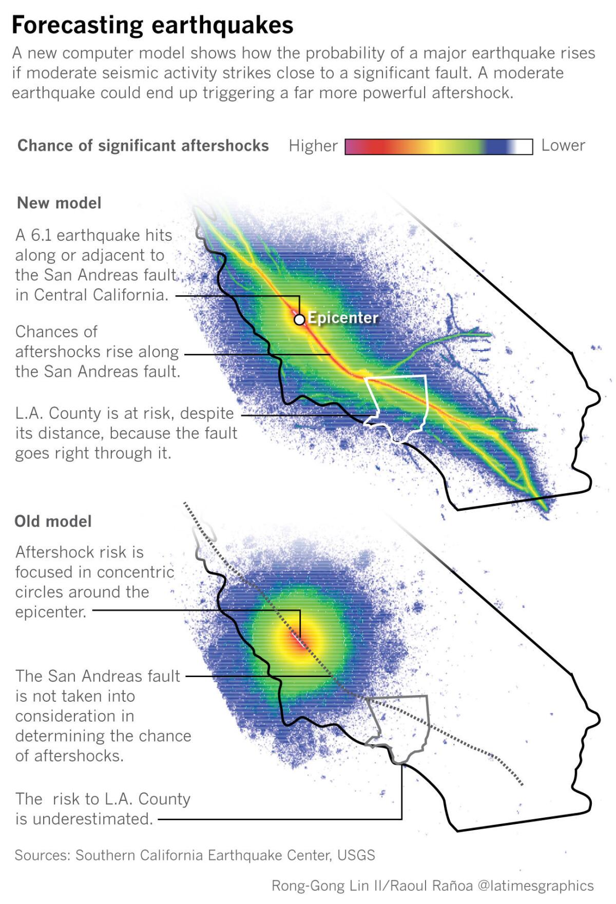
This effort got a major boost with the release of a one-of-a-kind statistical model for California about how one earthquake can trigger another — including one even worse than the original tremor. The results were in a report recently published in the scientific journal Seismological Research Letters, co-authored by 20 of the nation’s leading earthquake scientists, affiliated with agencies and academic institutions such as the U.S. Geological Survey, the Southern California Earthquake Center and the California Geological Survey.
The latest in operational earthquake forecasting will be discussed at the annual meeting of the Southern California Earthquake Center, which is being held in Palm Springs this week.
Jordan and others are quick to note that this earthquake forecasting system is far from foolproof — and cannot be used with certainty.
While half of all large quakes are preceded by smaller foreshocks, the other half are not. So California could easily experience a huge quake without any hint of earlier, smaller seismic activity.
Still, the new research has sparked excitement from the seismic community, which in recent years has been working to let the public know all it can about the latest advances in earthquake forecasting.
A striking example of how earthquake forecasting can be useful is if moderate earthquake activity was detected at the northern end of the southern San Andreas fault in Monterey County. The old model focuses the risks of subsequent seismic activity close to Monterey County. In fact, the risk of a major quake extends all the way to Los Angeles County, as the two counties are connected by the San Andreas fault.
No other model like this one exists around the world, Jordan said, as no other region has such a complete database of known faults and how they might react if a moderate quake struck very close to a large, sensitive fault that could produce a catastrophic temblor.
Hints of a mega-quake
Moderate quakes may be precursors to the Big One
Scientists have increasingly made the connection between small earthquakes near major faults and much larger seismic events.
Perhaps the most famous such incident is the last time Southern California endured a magnitude 7.8 earthquake, as chronicled by scientists Aron Meltzner and David Wald in the Bulletin of the Seismological Society of America.
The date was Jan. 9, 1857, and in hindsight, there were clues the Big One could come.
In the dead of night, about nine hours before the 7.8 quake hit, small earthquakes began occurring in this particularly sensitive spot — the northernmost terminus of the southern San Andreas fault. They shook dangerously close to the first domino of the fault.
Then, at first light — two hours before the Big One hit — a magnitude 6.1 earthquake struck. An hour later, at sunrise, a second moderate earthquake hit, a 5.6.
The quakes seemed to do the trick. It was around 8:24 a.m. that the Big One began its inexorable march south, starting in Monterey County and, like an extremely fast version of a hurricane, rushed all the way down to Los Angeles County in about two minutes. The Big One produced 355 times more energy than the earthquake that began at first light. The earthquake not only sunk trees in Stockton and Sacramento, but uprooted trees near what is today the Grapevine section of Interstate 5.
“Big earthquakes can come in clusters. And one can trigger the other,” said U.S. Geological Survey seismologist Ned Field, the lead author of the new forecasting model report.
Changing scientists’ views of aftershocks
Many small quakes may suggest increased seismic stress
Scientists used to think “aftershocks were negligible. We used to think aftershocks were just little earthquakes that followed the big ones, and who cares about something smaller?” Field said. In reality, though, “aftershocks can be larger.”
The new understanding rebuts the myth that moderate quakes relieve pent-up stress on an earthquake fault and postpone the prospect of a Big One. That’s wrong.
In fact, a cluster of small or moderate quakes could reflect “increased stress in that area,” Field said. And even the biggest earthquake has to start small. “If you have more little things popping off, you have more opportunities for one of those to grow into something big,” Field said.
There are more recent examples of how using such a system in prime time could be helpful to scientists and the public.
A moving pattern of quakes
How seismic activity migrated from a village to the city
In September 2010, New Zealand’s South Island was jolted by the magnitude 7.1 Darfield earthquake, which ruptured under sparsely populated land and caused two deaths.
For months, aftershocks struck. The benefit of hindsight showed how seismic activity traveled east. “It migrated towards Christchurch,” New Zealand’s third-largest city, Jordan said. Nearly six months later, a 6.2 aftershock struck directly underneath the city, and the death toll soared to 185 as concrete and other buildings collapsed.
Earthquake forecasts could be helpful if something similar happened in California and scientists started detecting a pattern of seismic activity migrating in a certain direction. “We want to be able to anticipate as best we can where problems” could be, Jordan said.
The latest description of the seismic model was published online in June and is known formally as the “epidemic-type aftershock sequence model” of the Third Uniform California Earthquake Rupture Forecast, or UCERF3-ETAS.
Not all small and moderate earthquakes are made equal. Most of the time, small and moderate earthquakes are not a big deal, Jordan said, “unless that small earthquake is occurring near a major fault like the San Andreas.”
The new seismic forecast model hasn’t yet been put into prime time. There is no website nor any formal way for Californians to see a map of updated earthquake probabilities around the state.
A trial run
How California got a test run in the new quake forecasting model
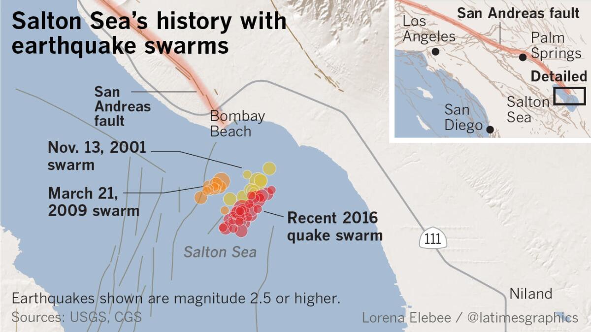
But California had a trial run with the system shortly after it became available for testing last year, when troubling seismic activity appeared near the Mexican border.
A series of moderate earthquakes suddenly ruptured at the southern terminus of the San Andreas fault beginning on Sept. 26. A rapid succession of small quakes — with three topping out above magnitude 4.0 — began striking near Bombay Beach and continued for more than 24 hours. More than 200 earthquakes had been recorded.
Setting off the first domino on the southern end of the San Andreas could unleash a bigger earthquake, unzipping from near the Mexican border through Palm Springs, the San Bernardino Valley and Los Angeles County, into Central California.
As a result, the U.S. Geological Survey issued a rare statement warning that the chances of a magnitude 7 earthquake or greater increased from a probability of 1 in 6,000 to as much as 1 in 100.
The statement caused some to react. San Bernardino officials decided to close down for two days their seismically unsafe City Hall, which had already been scheduled to be vacated in the coming months because of its risk of collapse in shaking.
How probabilities of major quakes can rise
How to understand seismic forecasts
Some critics question the usefulness of seismic forecasts.
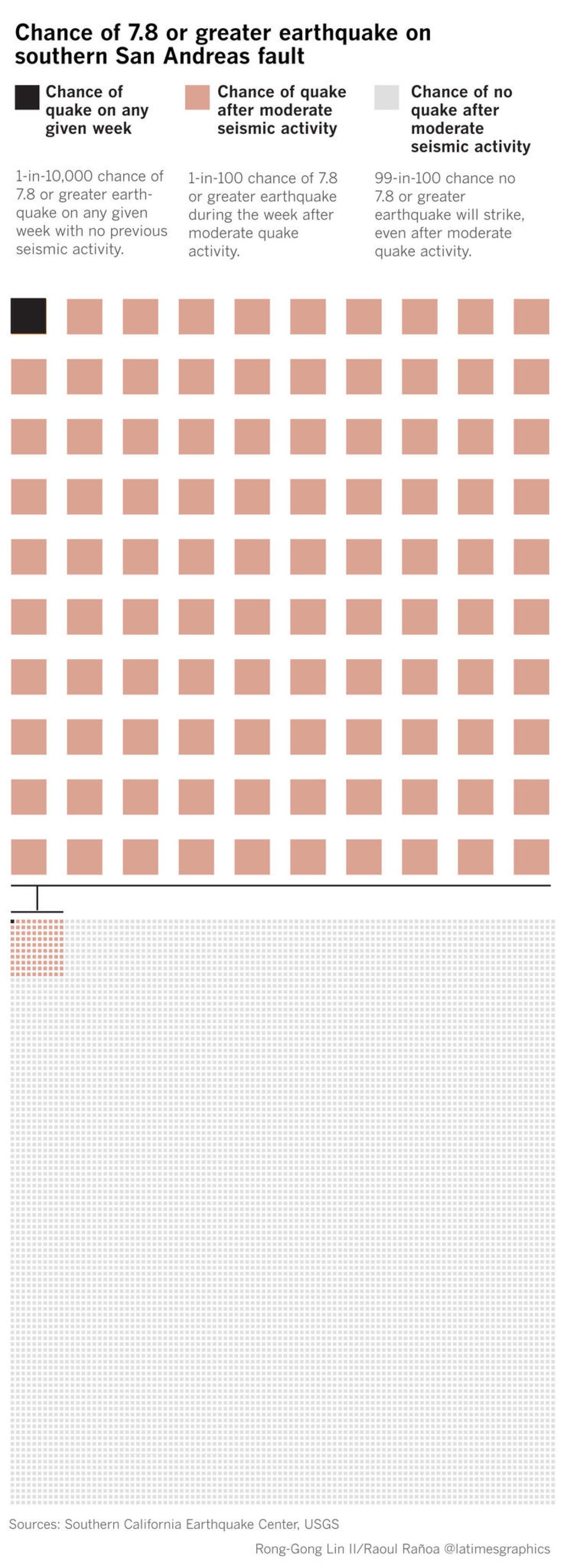
For instance, in any given week, there is only a 1-in-10,000 chance that a magnitude 7.8 or greater earthquake would strike the southern San Andreas fault, Jordan said. That chance rises dramatically to 1 in 100 after moderate quake activity strikes the fault.
But that still means there’s still a 99-in-100 chance that the large earthquake won’t happen during that particular week.
Still, Jordan says it’s better to communicate to the public what the seismologists know. A 1-in-100 chance of a mega-quake is “a much higher probability than on any given day,” Jordan said, “and therefore, if you’re very sensitive to earthquakes — if you run the power grid or something — you might be very interested in that.”

There are other limitations to the model. It needs to be tested to see how good it is at forecasting, Jordan said.
Lessons from Italy
The importance of accurate information
One reason why scientists think it’s important to clearly communicate what they know about earthquake forecasting is what happened when an earthquake swarm happened in central Italy in 2009, an incident Jordan wrote about for the journal Seismological Research Letters. In an effort to calm jitters, government officials held a news conference at the end of March “to reassure the public.” One official told reporters: “The scientific community tells us there is no danger, because there is an ongoing discharge of energy. The situation looks favorable.”
The statement was wrong — and at odds with what scientists know about seismic swarms. Lulled into safety, there was little public concern after a 3.9 earthquake jolted L’Aquila before midnight on April 5, 2009. A few hours later, a 6.3 quake struck, and more than 300 died.
Jordan said it’s important that authoritative announcements are sent out swiftly and accurately, especially in the age of social media.


Twitter: @ronlin
raoul.ranoa@latimes.com
Twitter: @ranoa
ALSO
Hurricane Harvey ravaged cars and trucks — bad for drivers, good for automakers
Video of UC Berkeley police seizing bacon hot dog vendor's earnings goes viral
Nearly 40,000 lightning strikes lit up the sky in southwest California
Sign up for Essential California
The most important California stories and recommendations in your inbox every morning.
You may occasionally receive promotional content from the Los Angeles Times.


