Snowpack levels surge in the Sierra Nevada, helping to power California out of drought
- Share via
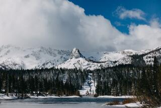
Plunging the long, metal rod into the snow beneath his feet in the mountain town of Phillips, state snow survey chief Frank Gehrke measured the Sierra Nevada snowpack Wednesday not against California’s recent, historic drought but against its biggest rain years.
“It’s in the top two or three, three or four snow accumulations for March,” Gehrke said, standing on a 9-foot-high pillow of fresh powder Wednesday morning.
Traditionally considered the end of California’s rain season, the April 1 snowpack is the bar by which the success of each year’s winter is measured. As of Wednesday, the average snowpack across the entire range was at 185% of normal conditions for the first day of March and at 163% of the April 1 average, the Department of Water Resources said. On the same date in 1983, the biggest year on record, the entire Sierra Nevada snowpack was estimated to be 175% of its April 1 average, officials said.
“It basically started snowing on Veterans Day and basically didn’t stop until Memorial Day” in 1983, Gehrke said. “If we get another series of storms, we may end up record-setting on April 1. We’ll just have to see.”
If there were a choice, state water officials would prefer more traditional winter storms that flow south from the Gulf of Alaska. Those bring the snow elevation down and pile up snow that will melt at a steadier pace throughout the year. Warmer storms, dubbed “atmospheric rivers” or the “Pineapple Express” because they flow east from Hawaii and the tropical Pacific, melt snow and send heavy amounts of water cascading down saturated hillsides, causing havoc on the communities below.
“My biggest concern, and just about everyone agrees with it, is with all the snowpack in the Sierra. If we get a warm rain this spring, we’re going to be flooded. There’s no getting around it,” Robert Mitchell, mayor of the Sacramento Valley town of Tehama, said in an interview last week. “It’ll be ugly down here, but there’s nothing you can do to stop it.”
Case in point was San Jose in February. A series of atmospheric rivers overwhelmed Santa Clara County’s reservoir and levees and flooded the heart of the city. The city evacuated more than 14,000 people.
Since the water year began Oct. 1, California has enjoyed a constant stream of atmospheric river events that have filled reservoirs and rivers and helped replenish aquifers. About 40% of the state’s water comes through atmospheric rivers, and in an average year, the state can count on about a dozen of them, said F. Martin Ralph, the director of UC San Diego’s Center for Western Weather and Water Extremes at the Scripps Institution of Oceanography.
During the last five years of drought, California received maybe six atmospheric rivers a year, he said. Since Oct. 1, the state has had about 30 atmospheric river events, he said.
“‘The storm door is open’ is something we sometimes hear,” Ralph said.
The results of the atmospheric rivers have been striking.
Isolated, low-lying towns along the Russian and Sacramento rivers have been flooded repeatedly over the last two months. Dozens of counties have declared states of emergency, and the state’s biggest reservoir, Shasta Lake, released water from its spillway gates for the first time in two decades last week. About an hour south in Oroville, in the shadow of the Sierra Nevada, conditions at the nation’s tallest dam were briefly perilous last month when the main and emergency spillways both suffered damage from torrents of water.
Along the San Joaquin River in Central California, which has a much smaller capacity than the rivers up north, levees were breached and sections of freeways and communities were underwater last month.
“I think at this point people would welcome a little bit of a respite,” Gehrke said of the storms. “The snowpack is a wonderful boon, but the rain and precipitation has certainly caused some issues and challenges for folks.”
Though no significant storms are expected across the state for the next week or so, California’s varied microclimates provide little certainty for forecasters. It’s likely there will be at least another atmospheric river making landfall in the next six weeks, given the wet winter, Ralph said.
According to Wednesday’s survey, the northern Sierra Nevada snowpack was measured at 159%, the central Sierra was at 191%, and the southern region was at a whopping 201% of the average for the date. The snow will equate to more than 45 inches of rain when it eventually melts and flows into the state’s rivers and creeks, experts predict.
“It’s going to be hard to avoid some problems,” said Maury Roos, the state’s chief hydrologist.
This winter has been California’s wettest in at least 20 years, and in some parts of the state it may be the rainiest in history, according to state data.
The federal drought monitor shows the vast majority of the state is out of its 5-year-long drought thanks to the downpours, and officials say many of California’s surface-level reservoirs are full for the season. The biggest variable is how much the water has helped groundwater basins, which have been pumped for decades – and at rates that caused ground to sink during the drought – and have not been precisely measured.
“Water is good. There’s a lot of it. It’s just too bad we can’t move some of it to some of the areas that really need it for groundwater recharge,” Roos said.
For breaking California news, follow @JosephSerna on Twitter.
ALSO
Angels Flight expected to reopen by Labor Day, officials say
Oklahoma’s earthquake threat now equals California’s due to man-made temblors, USGS says
Carjacking suspect who drove in reverse during police chase is taken into custody after standoff
UPDATES:
8 p.m.: Updated with background.
4:10 p.m.: This article was updated with comments from hydrology experts.
This article was originally published at 11:45 a.m.
More to Read
Sign up for Essential California
The most important California stories and recommendations in your inbox every morning.
You may occasionally receive promotional content from the Los Angeles Times.


