Q&A: First significant storm in weeks forecast to hit L.A. Sunday

The Golden Gate Bridge in San Francisco is reflected in a puddle Jan. 23.
- Share via
A fairly significant storm appears headed for Los Angeles this weekend, forecasters said, bringing an end to three weeks of mild and sunny weather that followed strong storms the first week of the year.
The weekend storm was expected to depart by Monday, with dry weather returning. It isn’t the start of a much-anticipated pattern of a convoy of storms many expect during this strong El Niño season.
But the storm could bring a risk of flash floods in recently burned areas, where a lack of vegetation could cause mud and rocks to flow downhill. High waves could trigger coastal flooding, beach erosion and even property damage on Sunday, and push snow and ice onto the Grapevine mountain pass section of Interstate 5 and nearby California 14. Here are some answers to questions about what’s going on:
What should we know about this weekend’s storm for Los Angeles?
Rain is expected across Southern California, but how intense it will be is still uncertain. The heaviest rain is forecast for Sunday; Los Angeles could see anywhere between 0.25 inches to 0.75 inches, while the foothills could see 1 inch to 1.5 inches, said Curt Kaplan, meteorologist in the National Weather Service’s Oxnard office.
Chances of rain increase through late Saturday, with the big rain event expected Sunday.
What about the surf?
“The main story will be the surf, actually,” Kaplan said.
Officials are warning of breaking waves of 20 to 25 feet high off the far northern coast Thursday, including Humboldt and Del Norte counties. “Never turn your back to the ocean. Stay off rocks. Stay back from the water,” the weather service warns for the San Francisco Bay Area.
Potentially damaging surf of up to 20 feet could hit California’s central coast Friday. Ventura Harbor could see waves of up to 15 feet on Friday and Saturday.
Why should I be concerned about the surf?
There could be dangerous rip currents that pull swimmers out to sea. Beaches could erode, even in normally dry areas. Winds could be a problem – gale-force winds could come on Sunday along the coast, with winds from the northwest so strong they could bring danger to not only small boats but larger vessels.
Will this storm finally bring the convoy of storms to L.A. that we have been promised with all this talk of El Niño?
No. Most of the rain should leave L.A. by Monday morning, Kaplan said.
Why has El Niño forsaken us?
El Niño has not forsaken L.A., experts say.
Why are they so sure?
El Niño is still huge, and it’s lasting much longer than it did during the last big event in 1997-98. And the heaviest rain events for California have been in February or March, so experts say: Be patient.
El Niño is the warming of ocean surface water about 1,000 to 2,000 miles south of California that causes atmospheric disturbances worldwide and changes in global weather patterns. It’s about 2.5 times the size of the continental United States, said Bill Patzert, climatologist for NASA’s Jet Propulsion Laboratory in La Cañada Flintridge. And it’s much larger right now than it was at this point in 1997-98, during the last strong El Niño, that brought double the rain and double the snowpack to California that winter.
Why do warm ocean temperatures so far away from California have an effect on our winter rains?
The warming of the central and eastern Pacific Ocean fuel a supercharging of the subtropical jet stream, a narrow band of winds in the atmosphere that starts in Japan and heads east.
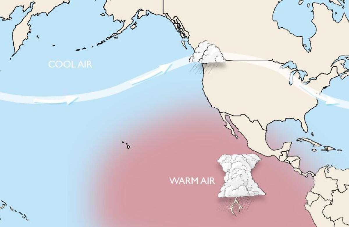
Typically, the subtropical jet stream weakens in the middle of the ocean, and storms aren’t forced to follow the path due east to California. They can veer north, hitting Oregon, Washington and British Columbia instead.
As a basis of comparison, take a look at this graphic. It shows what happens when El Niño is not influencing the path of the jet stream -- it veers northeast, off to Seattle.

The path of the jet stream when it is not influenced by El Nino.
The jet stream veers away from California when El Niño is not influencing it. The subtropical jet stream loses steam and the path of storms veers to the north. This image shows what the ocean looked like this autumn, when warming ocean temperatures do not influence the path of the jet stream. (Emily Underwood / California Weather Blog)
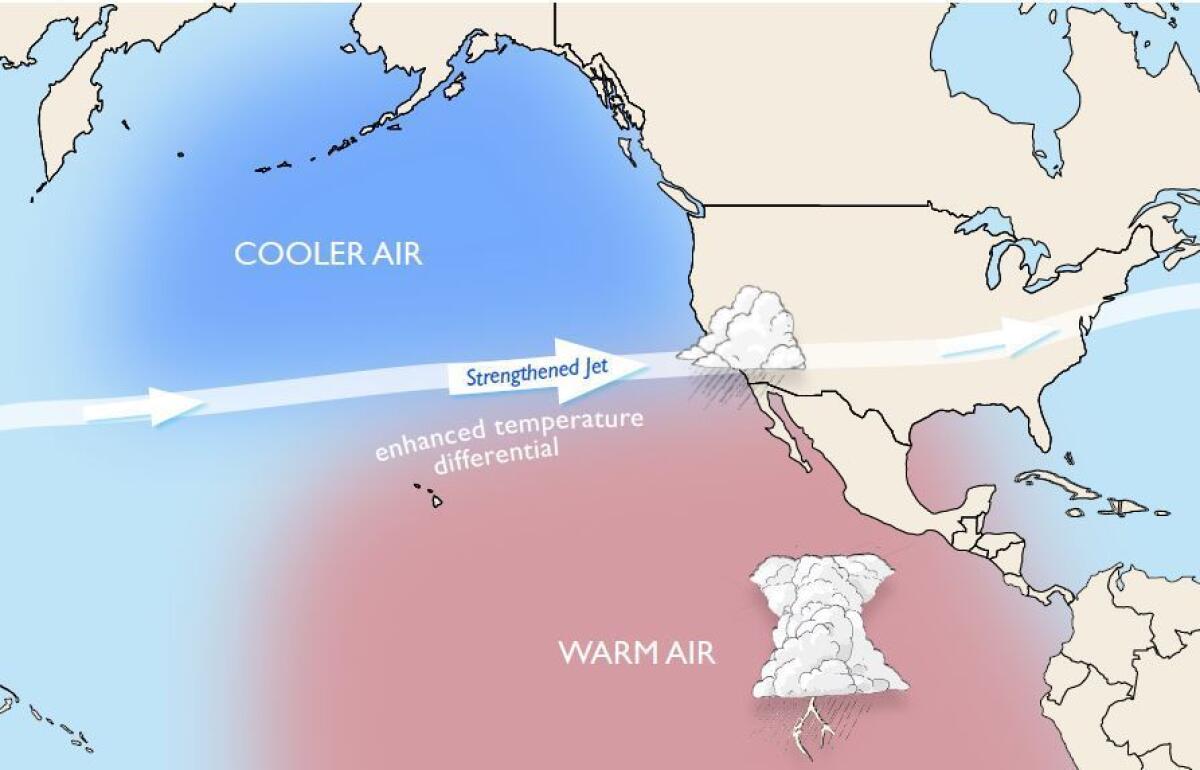
During a strong El Niño, the warmer temperatures fuels the subtropical jet stream, allowing it to last all the way to the southern United States, Patzert said.

The subtropical jet stream is supercharged by warm ocean waters and storms can reach California.
In the winter, the warmer ocean waters of El Niño strengthen the subtropical jet stream and straighten it out, instead of allowing it to veer off. The stronger jet stream pushes the path of storms toward Southern California. (Emily Underwood / California Weather Blog)
It’s that emboldened jet stream that allows storms to take a straighter, more direct path to the east – which happens to target Southern California in the winter, said Stanford University climate scientist Daniel Swain.
What has been keeping this jet stream away from L.A.?
A storm-repelling mass of high pressure typically southwest of California has been stronger than normal, Swain said, focusing the track of storms into northern and central California.
If the subtropical jet stream gets even stronger later this winter and the mass of high pressure weakens, that could allow a series of storms to get to Los Angeles, Swain said.
Has the atmosphere changed as a result of the warming of ocean waters in the Pacific Ocean?
Yes, Swain said. “As soon as January hit there was a big strengthening of a subtropical jet,” he said. “It’s very consistent with the picture we all had in our heads of what was likely to occur. So -- so far, despite the fact that it’s been dry in L.A., the atmosphere really is responding more or less as we expected it to. So we still expect that the rain will still come.”
What have been the heaviest months of rainfall during strong El Niño winters for L.A.?
In 1998, February was the big rain month. In 1983, it was March. Above-average rains could persist into May.
What does the National Weather Service say about the prospect of more rain for L.A.?
Kaplan, the weather service meteorologist, said he’s hoping that it’ll be later in February “when we’ll see storms line up one after another.”
“Even though we're not directly being hit, the subtropical jet has been strong across the Pacific. It’s just the line has been farther to the north. That’s why Northern California is getting the bulk of the rain,” he said. “We just need that thing to sag a little bit farther. And it will on Sunday, but it will be short-lived.”
“People are a little panicked but they shouldn't be,” he said. “We still have a very strong El Niño set up in the Pacific … and it’s still encouraging we’ll see quite a few storms come through between now and the end of March and even April.”
How will this storm affect Northern California?
The storm will be more of the same to Northern California, which has been seeing decent rainfall and snow since the start of the year. Between Thursday night and Sunday, San Francisco could see 0.25 to 0.5 inches of rain, and Sacramento between 0.5 inches and 1 inch. Eureka could see 2 inches to 3 inches of rain.
At Donner Summit near Lake Tahoe, heavy rain is forecast on Friday morning, and is forecast to turn into heavy snow between 10 p.m. Friday and 10 a.m. Saturday. Snow showers could dominate the rest of the weekend, with a second storm possible late Sunday.
Follow me for the latest news in earthquake safety, El El Niño, and the drought: @ronlin


