Here are some things to know about the extreme drought in the Western U.S.

- Share via
Almost half of the U.S. has been in a drought since the start of 2021.
Compounding factors, including low rainfall and snowpack, climate change and persisting droughts from previous years, have escalated into extreme dryness.
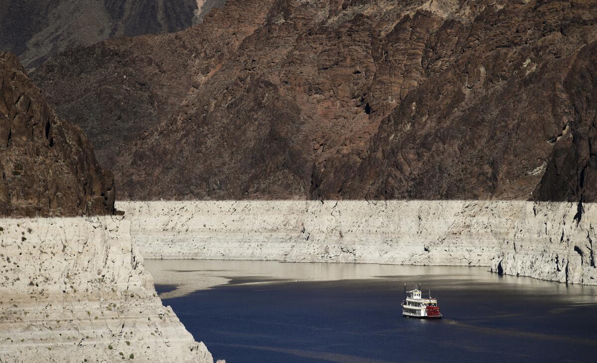
The prolonged dryness means low water levels are endangering fish species in Oregon and Colorado, 30% of California’s population is in a drought emergency, and the nation’s two biggest reservoirs on the Colorado River — Lake Powell and Lake Mead — are two-thirds empty.
“What we see in our major reservoirs on the Colorado River really give us a good indication of water and drought in the West, and whether we’re in a good or a tough spot,” said John Berggren, a water policy analyst at Western Resource Advocates, a nonprofit organization. “And right now, we’re definitely in the latter category.”
Such water shortages can encourage wildfire spread, force water use restrictions and stretch states’ power supply that rely on hydroelectric dams.
As the drought shows no sign of letting up, here’s a rundown of what’s happening and what may come next.
What is a drought?
The classic image that may come to mind when thinking about a drought is dry, cracked ground where perhaps a healthy river once flowed. Droughts can and do occur throughout every season of the year, and aren’t dictated by temperature, but rather moisture levels.
A drought occurs when precipitation is lower than normal, leading to a water shortage, according to Brad Pugh, a meteorologist at the Climate Prediction Center, a federal agency.
There are five categories of drought severity, determined by streamflow, soil moisture, rainfall and snowpack levels, and other factors. The least extreme is the abnormally dry category, growing in severity from moderate to severe, extreme and exceptional drought. An abnormally dry drought can lead to short-term dryness, slowing crop growth and lingering water deficits, while an exceptional drought creates widespread crop loss and water emergencies.
Which areas of the U.S. are being affected?
Almost every part of the Western U.S. is in a drought.
Montana, Idaho, Washington, Oregon, California, Nevada, Arizona and New Mexico are all experiencing extreme and exceptional droughts, the two most severe types, according to the U.S. Drought Monitor, a weekly drought map produced by the U.S. government and the University of Nebraska-Lincoln. A drought is classified in these categories if soil moisture and streamflow fall into the bottom 5th percentile of typical numbers, along with lower than average precipitation.
Colorado, Utah, North Dakota and Illinois are also facing drought conditions, said Curtis Riganti, a climatologist at the University of Nebraska-Lincoln’s National Drought Mitigation Center.
Although drought hasn’t struck all of the U.S., the dry conditions can create ripple effects throughout the country because agriculture and other industries are connected nationwide.
If you’re buying leafy greens during winter, there’s a high chance it was irrigated in California, Berggren said.
If droughts become more extreme, they could lead to higher prices for leafy greens nationwide — similar to how meat prices surged across the U.S. in spring 2020 when processing plants closed due to COVID-19.
What role does climate change play?
Climate change, caused by humans’ use of fossil fuels, deforestation and unsustainable agriculture, has raised air and ocean temperatures, increased the risk of forest fires and worsened air quality. The United Nations’ Intergovernmental Panel on Climate Change lists electricity and heat production, land use — including forestry and agriculture — and industry as the economic sectors emitting the most greenhouse gases.
Some climate researchers believe that climate change has pushed California into a “megadrought,” an intense drought that lasts for decades, although Pugh says the current drought conditions mirror typical 10-year trends.
Berggren said the drought is “unequivocally connected” to climate change.
“Droughts have been around in the West forever — that’s just a function of life in the West,” he said. “The connection is that climate change is making drought more common and making it more difficult for us to recover.”
Hot and dry autumns due to climate change lead to less soil moisture, which in turn make vegetation need more water — water that isn’t available due to drought.
Droughts versus heat waves
Much of the Western U.S. has been in the midst of a heat wave in recent days.
Drought conditions can often lead to heat waves, particularly in the summer. Low soil moisture from drought causes more evaporation and exacerbates high temperatures, Riganti said.
While droughts and heat waves can go hand in hand, they’re not the same thing.
Droughts are measured by water levels, but heat waves are determined by temperature. The World Meteorological Organization, a United Nations agency, defines a heat wave as when the daily maximum temperature is above the average maximum temperature by 9 degrees Fahrenheit for five days straight.
Drought, heat waves and wildfire
Dryness from drought and the high temperature from heat waves have analysts worried about fires. As heat builds and soil dries out, the dry ground becomes a place for wildfires to spark and spread.
In the Northwest, massive wildfires last year burned more than 1.6 million acres, killing at least 12 people and forcing tens of thousands to evacuate. Thousands of homes were destroyed in the fires, which cloaked the region in thick smoke for weeks.
Washington state has responded to 475 blazes so far on public land since the beginning of the year, compared with 318 by this time last year, according to the state Department of Natural Resources. Oregon is also seeing more fires than usual, and a warm, dry spring has produced drought conditions in both states as well as northern Idaho.
“The warm conditions have resulted in low snowpack, which is the case pretty much across the mountains in the West,” said Deepti Singh, a Washington State University climate scientist. “The heat and rapidly declining snowpack levels are both pretty certainly attributable to climate change.”
Drought-parched vegetation and forests overstocked with trees from decades of fire suppression are a flammable mix, she said.
In Oregon, water accessibility threatens native species and farmers’ crops
Analysts say drought can reduce cover, food and water sources, and habitat for wildlife. And droughts have caused some farmers to stop growing crops altogether.
In Oregon, native fish are dying and many farmers are cut off from their water supply.
The Klamath Basin, which stretches across Oregon and California, is a vital source of water for many. The Upper Klamath Lake houses two endangered fish species that hold significance for the Native tribes in the area both as a food source and in cultural importance.
Low streamflow in the Colorado River is also endangering four fish species, according to the Western Resource Advocates.
The fish have been dying due to several factors, including habitat destruction from agriculture and wetland loss. A compounding factor is the lake’s historically low water elevation. Many farmers use water from the lake for their crops, but with the drought, there isn’t enough water for everyone.
The Bureau of Reclamation announced that the canal feeding water from the lake to irrigators would be closed for the season, which means many farmers won’t have access to any water. Even with the canal’s closure, there still may not be enough water for the endangered fish, the bureau said in a press release.
Colorado River Basin reservoirs, ‘the lifeblood of the West,’ fall to record low water elevations
Millions visit Lake Powell each year, with many intending to boat on the lake. But tourists who visit it now may be disappointed; multiple launch ramps are closed because of low water levels.
Lake Powell also serves an important purpose other than tourism: It’s the country’s second largest reservoir, behind Lake Mead. The two reservoirs can together hold four years’ worth of annual Colorado River flow. The river provides water to more than 40 million Americans and 4 million irrigated acres of farmland.
And both reservoirs are only about a third full.
“A lot of people call [the Colorado River] the lifeblood of the West, and I think that’s true,” Berggren said. “It’s also the canary in the coal mine of the West.”
The water levels in the reservoirs dictate whether states get their allocated water supply. The Colorado River Basin Drought Contingency Plan will short states of their water if Lake Mead falls below certain water elevations.
The Bureau of Reclamation has forecast that the reservoir will hit a historic low of 1,065 feet by the end of 2021.
Times staff writer Richard Read in Seattle contributed to this report.
More to Read
Sign up for Essential California
The most important California stories and recommendations in your inbox every morning.
You may occasionally receive promotional content from the Los Angeles Times.


