2nd Snowstorm Hits Vermont; Midwest Chilled
A second early snowstorm hit Vermont on Sunday as a new wave of cold air dropped temperatures to record lows from the Rockies to the Great Lakes.
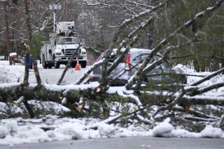
Snow advisories were posted over a large part of Vermont, where four inches of snow was reported in the Montpelier area and up to three inches fell along the Green Mountain chain, with up to six inches expected. Scattered power outages were reported, affecting about 1,000 homes.
Crews of utility linemen and state workers were still cleaning up the damage left by an unusually early and unexpected storm Oct. 4, which left an estimated 26,000 Vermonters without power. That storm also dropped about 20 inches of snow in adjacent areas of New York.
‘Just Unbelievable’
“This is getting a little old for October, I’ll tell you,” said Stephen Bravar, spokesman for Vermont’s largest electric utility, Central Vermont Public Service. “This is just unbelievable.”
Record lows were reported Sunday at more than 30 cities from Idaho to Michigan and as far south as Missouri, most in the teens and low 20s. To the south, Midland, Tex., tied its record of 44 degrees.
The low of 28 at Omaha, Neb., toppled a record that had been on the books since 1875. The lowest of the records was 16 degrees at Scottsbluff, Neb., and Waterloo, Iowa.
Afternoon temperatures were in the 40s and 50s across the Great Plains.
Frost advisories were issued for Indiana, with overnight temperatures expected to be near freezing. Freeze warnings were posted across western Ohio with frost warnings issued for the central and eastern sections of the state.
Rain and thunderstorms were also widely spread across the nation, from the coastal areas of South Carolina and Georgia through the Florida Peninsula. Key West got 1.83 inches of rain in six hours.
Isolated rain showers were spread over the Ozarks of south-central Missouri and north-central Arkansas. Rain was also widespread from New Jersey into eastern sections of New England.
Highs in the 40s and 50s were predicted for today across the Great Lakes, the Ohio Valley and New England and in the 80s over the southern Plateau and the Florida Peninsula.
More to Read
Sign up for Essential California
The most important California stories and recommendations in your inbox every morning.
You may occasionally receive promotional content from the Los Angeles Times.


