Hurricane Claudette, Compact but Intense, Moves Toward Bermuda
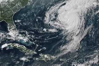
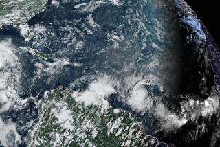
MIAMI — A small but intense Hurricane Claudette curved toward Bermuda on Saturday, its winds roaring at 120 m.p.h., and a hurricane watch was posted for the island.
“It’s a dangerous storm, it’s a powerful hurricane, but it covers a relatively small area,” said meteorologist Mark Zimmer at the National Hurricane Center in Coral Gables, Fla.
Tropical storm-force winds of at least 39 m.p.h. extended about 85 miles from the storm’s center.
“We’re looking for a pretty quick turn to the right, to the north. That will bring it in the vicinity of Bermuda,” Zimmer said. “The problem of course is just how close it will come to Bermuda.”
Forecasters said that it would take until midday today to get a good idea of how close Claudette would be to Bermuda, which is expected to be affected late today or early Monday.
With the hurricane’s course taking it over cooler water, forecasters expected a slow weakening over the next day or two. The system zipped from loosely organized thunderstorms Wednesday evening to a tropical storm Thursday and reached hurricane strength on Friday.
“It was really intensifying rapidly,” Zimmer said. “It now looks like it’s leveled off. We don’t look for any further intensification.”
The hurricane’s center late Saturday was about 315 miles south of Bermuda and was moving north-northwest at about 9 m.p.h.
A gradual turn toward the northwest was expected by noon today. A more northerly track could lessen the threat to Bermuda and take it east of the island on a path into the remote north Atlantic.
“We don’t see any threat to the mainland now,” Zimmer said. “With that turn to the north, we don’t see any threat right now to the East Coast of the United States.”
More to Read
Sign up for Essential California
The most important California stories and recommendations in your inbox every morning.
You may occasionally receive promotional content from the Los Angeles Times.


