TRAVELING IN STYLE : Gorgeous Gorge : Part Washington, Part Oregon, This Stretch of the Columbia River Is So Beautiful It’s Almost Dangerous
ON CERTAIN DAYS, IN CERtain kinds of light, I shouldn’t be allowed to drive in the Columbia River Gorge, because I can’t keep my eyes on the road. They dart back and forth of their own accord, spinning recklessly around to catch a chance combination of color, a barely seen waterfall tumbling off a cliff into air, a sudden bundle of lupine by the road--and, always, the Columbia River. The basalt headlands of the gorge brace the river, which itself forms much of the border between Oregon and Washington, for more than 55 miles--geologists quibble about its length--and for all those miles, it requires a constant shifting of focus.
One of the great virtues of the gorge is its beauty in any weather: One day the visitor sees shimmering sheets of rain, and the next day, sheets of light. The Columbia is still and reflecting, choppy and opaque, slate or jade. The sky is blue and flat and hot or busy with clouds. The massive cliffs can be matronly one moment, eldritch the next. Sometimes, for safety’s sake, I just pull off the road and park.
Mt. Hood, a snowy pyramid plucked from a storybook, can be seen from many of the gorge’s twists and turns, hovering over the great headlands on the Oregon side of the river. Mt. St. Helens used to be visible, too, over the sloping hills on the Washington side. Then it exploded itself shorter, and now the hills hide it. I don’t miss the sight, though. Its disappearance was such a poetic incident in the context of geological time that has made and marked the gorge.
All these vistas big and small are the result of volcanoes and floods and erosion, events violent and gradual and unending. Recently, I drove into the gorge on the north side, taking Washington 14 east from Vancouver, Wash. The two sides of the Columbia are distinctly different, and complementary. Oregon hogs the high, dramatic cliffs and waterfalls, and Washington gets the broad, empty, rolling hills. During the ancient deposits of volcanic debris, a little more of a particular slippery clay fell on what is now Washington. More recent debris slides off, so that Washington has the kind of curvaceous landscape that seems to beg for a galloping horse, with grass so green it looks like candy and watery dells full of birch, dogwood and rhododendron.
Whether I’m traveling in Washington or Oregon, whether I’m moving to the west or the east, I never come to the gorge without a sense of event. The gorge looks as if it has been planted there: The cliffs and hills rise up solid and green above the steady river, and I’m always struck with the same thought--that this brief portion of land is one of the planet’s gateways, and that I can’t pass by it but must pass through.
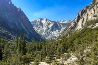
On one occasion, I left Vancouver early enough that fog still rolled over the river there, and I climbed up the two-lane highway until I emerged suddenly into sunshine. At mile 25 on the side of Cape Horn, a cliff named by explorers after another, more famous, sailor’s nightmare, there was just enough room on a blind curve to pull off the road and hug the completely inadequate guardrail. To the east, I looked into the textured walls of the gorge. Straight below me spread a delectable bottom land of grass and trees bearing every shade of green, with a tiny pair of railroad tracks curving around the bend. Mist rolled up in clouds off the wide, riffled river below, twisting away from the sun pouring in from the east. All the way across the water, I could hear the honking of Canadian geese, still hidden in the disappearing fog. That afternoon, having crossed the river about 90 miles further east and turned toward home, I drove into light, with halos behind every tree and a golden glow across the water.
This month marks the bicentennial of one significant, if slightly anticlimactic, event in the Columbia River’s human history. In May of 1792, navigator Robert Gray sailed across the bar at the river’s mouth and into the river itself, the first Euro-American to do so. ( The river is named in honor of his vessel.) Though Gray thereby proved that the great maw cut into Oregon’s coast was a river after all and not just an inlet, he traveled only a tiny fraction of the Columbia’s 1,200-mile length.
Lewis and Clark, of course, were the first Euro-Americans to pass through the whole gorge, in 1804, though they were alternately cheered on and ridiculed by the many American Indian tribes who’d lived here for thousands of years. The Columbia River was then broken by great rapids, cataracts and chutes of hard water pouring over boulders, creating legendary fishing beds. It didn’t take long to domesticate the raw river--our loss, I think. There were trains by the 1850s, then steamships and the highway, and, by 1938, the river was dammed at Bonneville and never the same again.
Today, there is an expressway up the gorge in Oregon--Interstate 84--running from Portland into Idaho and Utah and beyond. It offers speed and a river’s-eye view of the cliffs. But from Troutdale, just east of Portland, you can drive the old highway, the original feat of engineering finished in 1915. It merges with the freeway at the tiny town of Dodson, the only place I’ve ever seen where a thrift store advertises “secondhand docks.” The signs for the old highway warn “narrow winding road,” and they speak the truth; trailers aren’t welcome here.
On another recent trip into the gorge, my husband and I left Portland and drove up the old highway, past the view post at Crown Point and down along the cliffs themselves. Here the vistas are framed by branches, and, passing through, I always lean back under the comfort of close trees reclining over my head, slow down for the ferns brushing lightly against the car and stop altogether for the masses of wildflowers wet with trickling water.
There may be more major waterfalls here than anywhere else in the United States; the great Bretz Floods of the last glacial age tore so much soil out of these cliffs that dozens of rivers and streams were left hanging in the air, some hundreds of feet high. Eleven different falls, each more than 100 feet high, can be seen without leaving the car--but who wouldn’t want to get closer than that? There are many more waterfalls, of course--impromptu spills of melting snow bouncing down the cliff sides, spreading out across the hills. Winter and early spring is waterfall season. There are more than 200 miles of trails in the designated National Scenic Area and the smaller Wilderness of the Gorge. Most trails are free of snow year-round, and the cautious winter hiker will see many secret falls normally hidden by trees, some only a mile or two from the road.
This time, we were lazy and simply strolled past Latourell Falls and Mist Falls, past Bridal Veil Falls, lingering over the fairy dance of Wahkeena Falls. We didn’t even stop for the most crowded, the great cheering drop of Multnomah Falls. We clambered over boulders and fallen logs into Oneonta Gorge, passed Horsetail Falls and continued on into the town of Hood River.
Hood River hugs the hills below Mt. Hood and hides its many folds in acres of orchards. It’s a point of decision for the traveler. Highway 35 climbs above the billowing orchards into splendid stands of hemlock and ponderosa and lodgepole pine, then winds around the south side of the mountain past Timberline Lodge and heads south into the high-desert country. Highway 26 returns, through forests and the towns of Rhododendron, Zigzag and Welches, to Portland.
East of Hood River, across the Columbia from Biggs Junction, the land seems to sigh and open with light. On a bluff here is the Maryhill Museum, a vision of incongruity in this empty land. Legendary local attorney and businessman Sam Hill first had the idea to build a museum here, and the unfinished structure was dedicated, in 1926, by Hill’s friend, Queen Marie of Romania--in appreciation of the philanthropy of Hill and other Americans in her country after the First World War. A collection of Marie’s thrones, gowns and memorabilia fill the first floor. Maryhill also has one floor filled with Rodin bronzes and drawings, a large collection of chess sets from around the world, vases by Daum and Lalique and a fine collection of American Indian basketry.
One other choice is open to the traveler, and that’s to stay in Hood River, preferablyat the Columbia Gorge Hotel, which is what we did. We settled in here in a third-floor room above the river, above yet another waterfall tumbling off yet another cliff into the river. The growing wind made little whitecaps like flecks of cream on the water. (This is the windsurfing center of the gorge. Lessons are available, and several international competitions are held here. It was here, too, that the American record of 47 m.p.h. was set.) We lingered over dinner in the hotel’s excellent dining room, sampling local salmon, tea-smoked pheasant and a transcendent apple tart, followed by a pear eau de vie made nearby. Late in the evening, we walked through the grounds. We leaned over the waterfall, sniffed the masses of daffodils, teased the ducks quacking irritably at us under their breath.
In our room that night, we cranked open the bathroom window all the way and watched a barge slide silently by, far below, and heard the distant whistle of the train. We fell asleep at last, touched by the aquatic breeze and the low, nearby mumble of falling water.
GUIDEBOOK: Along the Gorge
Getting there: United, Alaska and Delta airlines offer daily nonstop flights to Portland from LAX. Alaska Airlines also flies nonstop to Portland daily from Ontario, Burbank and Orange County. The Columbia River Gorge extends eastward from around Troutdale, via Interstate 84 or the Columbia Gorge Scenic Highway on the Oregon side or Washington 14.
Where to stay: The Columbia Gorge Hotel, 4000 W. Cliff Drive, Hood River, Ore. 97031, (503) 386-5566; for reservations call (800) 345-1921. Rates: $175-$225, including farmhouse breakfast. The hotel is about 60 miles east of Portland--about an hour’s drive on the I-84.
What to do: For information on various local events planned in honor of Robert Gray in the coming months, call the Columbia River Maritime Museum in Astoria, Ore., (503) 325- 2323, or the Oregon Historical Society in Portland, (503) 222-1741. The Maryhill Museum of Art, 35 Maryhill Museum Drive, Goldendale, Wash. 98620, (509) 773-3733, is open daily from 9 a.m. to 5 p.m. from March 15 through Nov. 15. An exhibition of American Indian art from the region, “Ancient Images of the Columbia River Gorge,” runs through July 19 at the museum. For information on windsurfing equipment rentals, lessons and competitions, call Sailboards Hood River Ltd., (503) 386- 5363; Big Winds, (503) 386-6086, or Gorge Windsurfing, (503) 298-8796.
More to Read
Sign up for The Wild
We’ll help you find the best places to hike, bike and run, as well as the perfect silent spots for meditation and yoga.
You may occasionally receive promotional content from the Los Angeles Times.


