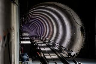
NEWS ANALYSIS : Politics Is Driving Force Behind Red Line Route : Transit: Path of subway, which opens today, may not be the most logical, but it’s the one that could be funded.
Transportation planners and elected officials faced a somewhat sticky dilemma when they sat down 10 years ago to map out the route for the Metro Red Line subway.
The logical route went through what planners considered Southern California’s regional core, a dense five-mile-wide swath of high-rise office towers and multistory housing on Los Angeles’ Westside. It had the nation’s busiest bus route, Wilshire Boulevard, and the world’s busiest freeway, the Santa Monica.
But by the time it left the drawing board, the subway--the first segment of which is scheduled to open today--was designed to go west only briefly before bending north and east to Hollywood and twisting north and west to the San Fernando Valley. Transit planners laughingly called it the “wounded knee” alignment because it looked like a broken leg.
How it got that way is a tale of politics as much as planning. The route--which has changed radically once more, again because of politics--may not be the most logical path. In the end, however, it was a route that generated enough popular support to get funded.
“Politics is an animal that can never be ignored,” said Doug Low, a design consultant who worked on the subway at the RTD from 1979 to 1990. “Nothing but politics determined where the line goes, which is very typical in transportation.”
Despite long odds, the first segment is ready to open, the second is well under construction and the third is promised funding. And, local officials said, Los Angeles has a basic system from which it can expand service to areas most in need of better public transit.
Many factors pull and tug on modern subway design. They determine why trains in Los Angeles will stop within a short walk of, say, the Museum of Contemporary Art and the Wiltern Theater, but no closer than a half-mile of the Los Angeles County Museum of Art and the Hollywood Bowl. Why trains will run to El Segundo and Norwalk, but not to Dodger Stadium or the Forum. And why one of the county’s least-congested commuter routes, between Long Beach and Los Angeles, wound up with the county’s first train line.
The factors that drive these decisions range from commuting patterns and computer models to the immutable laws of physics and plain old luck.
And, in the end, there is politics.
Politics--the push and pull of competing communities--is one reason why rail lines radiate in nearly every direction in the county’s 30-year, $185-billion plan for transportation improvements.
Politics--the worry that a careful consensus could collapse--is why people only whisper about the possibility that the recession could postpone and possibly erase some of those lines.
Politics--the dictates of public opinion--is deciding whether the San Fernando Valley will have an elevated train line above the Ventura Freeway or a subway under Chandler Boulevard.
And politics is a major reason why the first segment of the Red Line is only 4.4 miles long. It is as far as builders could go with the limited funds allocated by skeptical federal officials after ideological battles on Capitol Hill in the mid-1980s.
Broad local support for the system was vital to obtaining federal money, which is paying roughly half the cost of the subway. The Westside might have been the most logical route to planners, but it had almost as many political rivals as potential riders. Research notwithstanding, decision-makers at the RTD and in Los Angeles City Hall assumed that the rest of the county would never support a subway serving the Westside alone.
“If we’d chosen to go out only on Wilshire Boulevard, can you imagine the outcry of people in the San Fernando Valley who were paying a half-cent sales tax (for transit improvements)?” Mayor Tom Bradley, the subway’s most consistent booster, said this week. “Can you imagine (the reaction in) East Los Angeles or Pasadena? They’d be up in arms.”
The decision, then, was to route the Red Line to serve a larger number of different transit--and political--constituencies. So, Hollywood and the San Fernando Valley were added to the route, while promises were made to add extensions to the Westside and Eastside and to use local and state funds to build rail lines in broad “transit corridors” throughout the county.
As today’s scheduled opening ceremony testifies, the compromise worked.
“It’s not all (decided by) politics; typically it is a mix of factors,” said Rick Richmond, executive director of the Los Angeles County Transportation Commission from 1978 to 1988. “But politics do play a role--and I mean politics in the non-negative sense. You are using public money, so the elected officials should have a say in how it is spent.”
LACTC Executive Director Neil Peterson concurred. “It’s absolutely appropriate for local officials to make these decisions, based on community needs,” he said.
Some critics, however, wonder how “community needs” are defined.
For example, after voters approved Proposition A in 1980, giving the county $400 million a year from a half-cent sales tax surcharge specifically for transportation improvements, local officials set out to pick which of many promised rail transit projects should be built first.
Many factors were considered, including availability of land, relative ease of construction and expected ridership. But several people involved in the decision said one factor dominated: The wishes of former Supervisor Kenneth Hahn, author and tireless promoter of Proposition A.
And Hahn wanted the line to go from Los Angeles to Long Beach.
“Kenny Hahn was really pushing it--and he was the father of Prop. A,” said John A. Dyer, former general manager of the Southern California Rapid Transit District and now a senior vice president of ICF Kaiser Engineers in Los Angeles.
“That was my baby,” said Hahn, who retired last year after serving 40 years on the Board of Supervisors. “It goes through my district--Compton, Willowbrook, Watts. I said that line has to go first because I wrote Prop. A that gave them the money to build the system.”
The Red Line was being designed even as the Blue Line route was chosen. The money made available by Proposition A could have been used to expand the Valley-bound Red Line to include a branch under Wilshire Boulevard toward Westwood--through the heart of the dense regional core.
But in the face of Hahn’s popularity, no one suggested it.
“There was no political person on the (county) Transportation Commission to sponsor it,” Hahn said. “You always need someone on the commission to support a particular line, or it never gets built.”
Other political concerns favored the Long Beach line. County officials said they were eager to build the first rail line as quickly as possible, to show voters some tangible benefit from the self-imposed tax. The Long Beach line--using the largely intact route of the last Pacific Electric Red Car trolley, which was shut down in 1961--promised quick results.
That proved invaluable in 1990, when transit officials sponsored a ballot measure to double the county sales tax surcharge for transportation. The election was five months after the Blue Line opened. Voters narrowly approved the tax while voting down virtually every other spending proposal.
Even after a route is selected for construction, politics influences precisely where it goes and where it stops.
Once the Red Line stretches out to its full 22.7-mile length sometime in the coming decade, trains speeding between the city and the Valley will pass within a few hundred yards of the Hollywood Bowl. But despite years of lobbying by music lovers, there will be no Hollywood Bowl station.
City officials and transit planners consider such “specialty” stations--whether they are near cultural facilities such as the Bowl or sports arenas such as Dodger Stadium--a poor bargain.
“You’d be spending $50 million to $60 million for a station that accommodates maybe 2,000 people a day,” Dyer said of a Hollywood Bowl stop. “It was not cost-effective, and it would have made it hard to get the whole (Red Line) project funded.”
“In general, what you have to look at with these specialty centers is: How well does it fit in with the basic bread-and-butter goal of the system . . . getting people from home to work and back?” Richmond said.
Even if planners wanted a Bowl station, engineers said there was no way to connect it to a planned east-west station a mere three-quarters of a mile due south on Hollywood Boulevard. Impossibly tight turns would be needed to connect the two stations, they said, and politicians said there was no way to relocate the Hollywood Boulevard station.
Gary Spivack, planning director at the RTD, said the city of Los Angeles was using the Hollywood-Highland station to lure developers to the area--and the lure required a subway entrance on each corner of the intersection.
While the politics of neighborhood redevelopment has sometimes dictated where stations such as Hollywood-Highland were located, the equally powerful politics of neighborhood preservation have been credited with eliminating other stations and even rerouting the entire line.
A station once proposed for the intersection of Wilshire and Crenshaw boulevards sank under the protests of wealthy Hancock Park homeowners and residents, RTD and city officials said.
“They simply didn’t want a stop at Wilshire and Crenshaw,” Bradley said, “because of their fear that the various ‘elements’ who are attracted to a major stop like this would spill over into their neighborhoods.”
The “elements” were never described explicitly, the mayor said, but he believes they included African-American families living farther south on Crenshaw Boulevard.
Meanwhile, city and RTD officials privately contended that fear about development pressures further down the line, around three stations proposed for Fairfax Avenue, bolstered Rep. Henry A. Waxman’s opposition to the subway in general and to the Fairfax route in particular.
Waxman eventually forced a significant reconfiguration of the Red Line route--bypassing the Miracle Mile district and the county art museum--citing a fire danger posed by naturally occurring subterranean methane gas pockets. The gas was blamed for a clothing store explosion and a number of small fires in the Fairfax district in 1985, although engineers and tunneling experts generally downplayed any gas risk to the subway.
The cross-town Green Line route was shaped by a different type of politics, one designed to accommodate major aerospace companies.
For most of its 20-mile length, the Green Line--which is scheduled to open in 1994 or 1995--will operate its trains in the median of the new Glenn Anderson Freeway between Norwalk and El Segundo. Near the beach, it will turn southward, away from what many riders might assume was a natural destination--Los Angeles International Airport.
The reason is simple: The area’s aerospace companies--major employers, even now--complain that increasingly congested freeways frustrate workers and increase absenteeism. The political decision was that rail transit service to those offices is more important than providing a new and convenient link to the airport.
The county transportation commission is still trying to figure out how to fit a branch line to the airport--or, more likely, to a parking lot near the airport--into its 30-year budget.
“The number of people who would take rail to the airport on a daily basis won’t compare to the number of people who will go to El Segundo to work,” Peterson said.
“There is always a lot of political action in Los Angeles over who gets their piece of the transit pie,” said Jonathan Richmond, a transportation adviser to Supervisor Mike Antonovich and a postdoctoral scholar at the Massachusetts Institute of Technology.
“The 30-year (transportation improvement) plan isn’t a planning document, it’s a financial document. It’s a plan for spending money,” he said. “It isn’t based on any rational approach to solving transportation problems. It’s based on political pragmatism.”
The Red Line
T he Metro Red Line is Los Angeles’ first modern subway system. The initial 4.4-mile segment of the Red Line, which runs from Union Station to MacArthur Park, opens today . The $5.3 - billion project, being built in three segments, will eventually travel 22.7 miles. Today, trains will operate from 1 to 5 p.m., and Sunday, from 9 a.m. to 5 p.m. As of Monday, trains will operate every 10 minutes from 5 a.m. to 7 p.m., seven days a week. The first two days will be free, and the fare for the next month will be 25 cents. The regular fare is $1.10.
SUBWAY INFORMATION
Security: Officers on cars and platforms.
Services: No bathroom facilities or food outlets.
Travel time: Union Station to MacArthur Park, seven minutes.
Connections: After the first two days of free fares, Blue Line passengers can purchase a 25-cent transfer to connect at the 7th Street/Metro Center station. Red Line passengers can also purchase 25-cent transfers to connect with RTD buses at stations along the way; Red Line passengers transferring to the Blue Line must pay the full fare. Metrolink passes or tickets will be honored for Red Line connections at Union Station.
Tickets: Available from vending machines at stations. Monthly passes, good for bus and Metro Rail transportation and some transit agencies, are available. Tokens are also available.
WHAT’S NEARBY
Station: Union Station
Address: Alameda Street at Sunset Boulevard
Background: A major transportation hub with connections to the Metrolink commuter line, public transit, park-and-ride lots and a “kiss-and-ride” drop-off point. Near Olvera Street and El Pueblo de Los Angeles.
Station: Civic Center
Address: 1st and Hill streets
Background: Near Los Angeles City Hall, county offices and courthouses, shopping areas and Little Tokyo.
Station: Pershing Square
Address: 5th and Hill streets
Background: Near the jewelry center, major business areas.
Station: 7th Street/Metro Center
Address: 7th and Flower streets
Background: Near the financial and central business districts. Passengers can transfer here to the Metro Blue Line, which goes to Long Beach.
Station: Westlake-MacArthur Park
Address: Wilshire Boulevard and Alvarado Street
Background: Near MacArthur Park, has a “kiss-and-ride” drop-off point.
Compiled by Times researcher Nona Yates
Source: L.A. County Transportation Commission, Southern California Rapid Transit District
More to Read
Sign up for Essential California
The most important California stories and recommendations in your inbox every morning.
You may occasionally receive promotional content from the Los Angeles Times.


