Thousands in Florida Flee Fast-Developing Gulf Storm
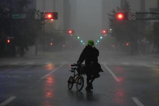
MIAMI — Fast-growing Tropical Storm Josephine neared hurricane strength Monday as it barreled into the Gulf Coast of Florida, scattering thousands of surprised coastal residents who raced inland to shelters.
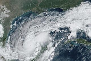
The storm, which three days ago was just a meandering area of low pressure off the east coast of Mexico, developed rapidly and began racing toward a landfall near Apalachee Bay, south of Tallahassee.
“We’re ready,” said Nancy Clifton, owner of Deep Water Marina in Apalachicola, where boats had been retied to their moorings, stores closed and windows boarded over with shutters and plywood. “Now we leave it up to nature.”
With top winds of 70 mph, the 10th named storm of the hurricane season was expected to generate a storm surge of 5 to 8 feet above normal, cause flooding over vast reaches of a Sunshine State already saturated by days of rainfall and spread thunderstorms and blustery weather into Georgia and the Carolinas today.
Josephine was also kicking up high seas and strong east winds on the Atlantic Coast of the southeast United States.
“We knew Friday that this could develop into a storm but we did not expect it to come this fast, this far, this soon,” said Clay Olson, a spokesman for the emergency operations center in Taylor County, in Florida’s Big Bend area, where 4,500 residents were evacuated from beachfront homes and trailers.
Forecasters at the National Hurricane Center in Miami warned that a storm surge could pose the greatest danger, as it did in 1993 when a powerful March storm--which became the “storm of the century” blizzard when it reached the northeast United States--caused 10 deaths in the sparsely populated counties of northwest Florida.
Despite that history, and ordering evacuations, not all coastal residents were willing to move. “We ask them for their next of kin and that sort of gets their attention,” said Olson. “But some just refuse to leave.”
Josephine earned her name as a tropical storm late Sunday, when sustained winds reached 39 mph, and spent most of Monday growing stronger while rapidly rolling toward a collision with Florida’s northern Gulf Coast. Tropical storm warnings were hoisted for most of Florida’s west coast, as well as along the eastern seaboard from central Florida to the North Carolina-South Carolina border.
Because of intense thunderstorms embedded in the storm, a tornado watch was issued for all of Florida. Throughout the day, several twisters were reported, including one that reportedly blew out the windows of a vintage car dealership in Naples on Florida’s southwest coast.
“We’re having to scramble with the rapid intensification of the storm,” said Mike Rucker of Florida’s Emergency Management Division.
Evacuation orders were posted for parts of nine Gulf Coast counties and some schools were closed.
In Atlanta, National Weather Service meteorologist Matthew Sena said that the storm was expected to track across Georgia overnight with gusty winds that could topple trees and down power lines. “The possibility of tornadoes is always a major concern when a tropical storm makes landfall,” added Sena.
Flash-flood warnings were posted for much of Georgia and South Carolina. Heavy rains associated with the low-pressure system that spawned Josephine were blamed for two deaths over the weekend in Brownsville, Texas, as well as flooding in parts of southwest Louisiana.
By late today, the remnants of Josephine are expected to merge with another low pressure system sweeping into the southeast from the north. Together, these systems will form a nor’easter and bring wet weather to much of the eastern United States through the rest of the week, forecasters said.
Times researcher Edith Stanley in Atlanta contributed to this story.
More to Read
Sign up for Essential California
The most important California stories and recommendations in your inbox every morning.
You may occasionally receive promotional content from the Los Angeles Times.


