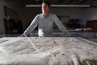
All the world in a Goleta warehouse
Goleta, Calif., may not look like one of the most important places in the world, but for people who wouldn’t dream of leaving home without a map, it’s the nexus.
Map Link, said to be the biggest map wholesaler in North America with 100,000 maps in stock and 70 employees, makes its unassuming home there in an old lemon-packing warehouse just off U.S. 101. My dream is to get locked in overnight.
The warehouse floor is about half the size of a football field, lined with shelves full of maps. Those published by the big guys -- Rand McNally, Langenscheidt, Michelin -- are toward the front; the ones from small specialty publishers -- Coop’s, which does a U.S. dinosaur site road map, and Ephemera Press, creators of a Harlem Renaissance map -- are at the back. A whole section of the warehouse is devoted to the U.S. Geological Survey. Apart from the USGS itself, Map Link is the only distributor that stocks the full series of 60,000 USGS topographical maps.
I recently visited Map Link and watched the company’s co-founder and president, Bill Hunt, fold a Beverly Hills Quadrangle USGS topographical map, complete with Desilu Studios in Culver City and St. Martin of Tours school in Brentwood. It was pure magic.
Hunt is also proficient at refolding maps, something I find impossible. Maybe that’s because he had a passion for maps even before he could tame his blond cowlicks as a kid in the Huntington Beach area. “They had lots of information, and I could get them for free,” Hunt said of the maps.
When he was 10, he wrote letters to 1,000 chambers of commerce around the U.S. requesting maps and, by 17, he had a collection of 30,000 topos.
Hunt is a self-professed map nerd who, with his then wife, Laura Ericson, started Pacific Travellers Supply in Santa Barbara in 1984. They sold travel guidebooks aplenty, but they found that foreign maps simply weren’t available.
While vacationing in Brazil in 1985, they bought 500 maps, which sold in short order. That spurred further trips abroad in search of hard-to-procure maps, an enterprise that Hunt calls “map running.”
By 1989, the map side of the business had outgrown back rooms in the shop and moved to a warehouse. Two years ago, Hunt and Ericson sold the downtown Santa Barbara store to devote themselves wholly to wholesale map dealing.
Most of the maps they stock are from map publishers, which proliferate in Western Europe, especially Germany. It takes only an e-mail or a fax to order those. But to get the most detailed maps for off-the-beaten-track places in developing countries, Map Link sends trusted employees on map-running trips as far afield as Zimbabwe and India, where they buy from government mapping agencies.
Hunt, who recently went to Indonesia to buy maps from the government mapping agency called Bakosurtanal, south of Jakarta, says that dealing with bureaucrats in small developing nations can be time-consuming and complicated, requiring patience and, occasionally, bribes.
“Almost every country has its own mapping agency,” says Hunt, “but in some places -- for instance, the entire Arab world -- they’re not allowed to sell their maps.” Such restrictions stem from the fear that government agency maps will fall into the hands of foreign aggressors.
“The USSR used to have two series of topo maps, one with military facilities noted, the other without,” Hunt says. “The Moskva River was rerouted on these to conceal the headquarters of the KGB.”
The National Imagery and Mapping Agency (part of the Department of Defense) creates maps of foreign hot spots for military and security purposes, using information gathered by intelligence operations and satellites. The most detailed are not available to the public. But Map Link stocks some products that are “as good as you can get for places where maps are forbidden,” Hunt says.
Maps, as it turns out, are powerful things that can spill all kinds of secrets. Hunt has driven thousands of miles to field-check state road and recreation atlases for California, Nevada, Arizona, Utah, New Mexico, Oregon and Washington (co-produced by Map Link and Allan Cartography in Medford, Ore.). Working on a highly detailed topographical section near the border of Nevada and Utah, he discovered a reclusive sculptor and some polygamists who did not want their ranches pinpointed in the atlas.
Many maps are hopelessly outdated and riddled with errors. This is partly because they’re time-consuming and expensive to create. It took the USGS more than a century to complete its topographical series of the U.S., at an estimated cost of more than $2 billion. Even these are imperfect because they lack updates and field checks, Hunt says.
Hunt thinks the best maps are made in Europe, where geography education is deemed more important than in the U.S. Of course, European residents are rarely far from a national border and tend to travel. “Americans are provincial. Lots of us never leave the country,” he says.
You don’t have to leave the U.S. to appreciate some of Hunt’s favorite maps. Among them is a huge laminated relief map of California produced by Raven Maps and Images, part of Allan Cartography in Oregon. It is beautifully colored in greens, yellows and oranges and shows our fair state from Mt. Shasta to the Salton Sea, with the long, low valleys of the Sacramento and San Joaquin rivers in the middle, ringed by mountain ranges. Although it was $45, I had to buy it. I’m going to find a place to display it in the office, to remind myself of something Hunt clearly knows: If you have a map, you have the world.
More to Read
Sign up for The Wild
We’ll help you find the best places to hike, bike and run, as well as the perfect silent spots for meditation and yoga.
You may occasionally receive promotional content from the Los Angeles Times.


