Levee breach in Monterey County triggers massive flooding, prompts evacuations, rescues

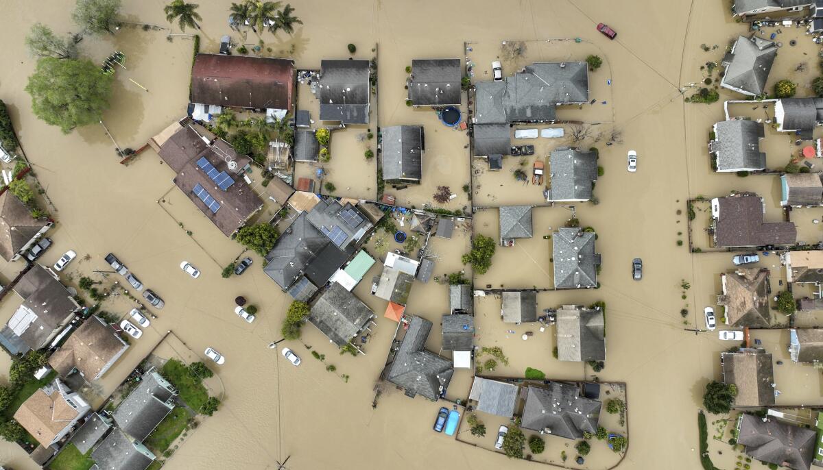
PAJARO, Calif. — A levee failure on the Pajaro River in Monterey County triggered massive flooding and prompted hundreds of evacuations and dozens of water rescues as the latest atmospheric river storm pummeled large swaths of California.
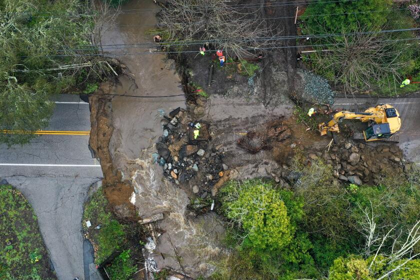
The levee — three miles upstream from the town of Pajaro — breached late Friday night, said Nicholas Pasculli, a Monterey County spokesperson. Patrols noticed “bubbling up in the adjacent farmland” at 11 p.m., the first sign there was a problem.
Thirty minutes later, the levee failed, Pasculli said. As of Saturday morning, he said, “the failure is approximately 100 feet wide.” The town of Pajaro — with a population of 1,700, mostly farmworkers — is underwater.
Authorities conducted 60 rescues that included the use of high-water vehicles, the sheriff’s diving team and the California Department of Forestry and Fire Protection’s swift-water team, officials said. National Guard personnel were dispatched to assist. At least 96 people were placed in county shelters.
Pajaro weathered previous storms because a flood wall in the lower part of the levee held up, said Monterey County Supervisor Luis Alejo.
“We had avoided just barely, by the grace of God, the flooding of the community,” Alejo said of recent storms. Residents were ordered to evacuate Friday afternoon, but some didn’t, he said, because they “were hoping that the worst would not happen because the levee did not breach during the last set of storms.”
“This is a disadvantaged community that often doesn’t get the attention it deserves,” Alejo said. “These are our friends, our neighbors, these are people that we really care about, and we know that they’re going to go through some tremendous hardship over the next several months.”
President Biden, in a phone call Saturday to Gov. Gavin Newsom, said California will have the “full support of the federal government” when responding to the devastation caused by the storms, according to a spokesperson for the governor.
On Saturday afternoon, crowds of onlookers stood on the Watsonville side of the Pajaro River Bridge watching the swollen, muddy river rushing below and the submerged town of Pajaro on the other side.
Sheriff’s deputies, county divers and boat rescue crews were parked along the bridge, behind yellow tape. Law enforcement officials stopped those with relatives or businesses on the other side, as well as the merely curious, from crossing.
One man, who declined to provide his name, said his grandmother was stuck on the other side in a flooded home. Authorities would not let him cross but took down her address and promised to check.
Connie and Victor Alvarez said they were trying to get in to check on their business, Alvarez Collision and Paint. They said they’d been notified by Monterey County that the business was likely flooded, and there was concern that toxic chemicals and solvents could be getting into the water.
“So, we’re here to check,” said Connie Alvarez, as she waited for a sheriff’s deputy to see if she had permission to cross.
Three blocks upstream, on the other side of a flooded area, three people were walking east along the river, carrying black plastic bags. Javier Gomez, a legislative analyst for Alejo, said they were likely among the residents who didn’t heed the evacuation warnings.
“I don’t know how many stayed,” he said. “But we’ve been doing back-to-back rescues all day. Feels like there were at least 100.”
At the Santa Cruz County fairgrounds, about 150 evacuees from Pajaro were talking, drawing, going through donated clothing and blankets and getting ready for what they guessed would be a stay of at least a few weeks.
Monterey County Sheriff’s Deputy Mike Hampson said many of the same people had been evacuated in January, when the river got high.
“At that time, they were displaced for about a week,” he said, noting that this time it’s likely to be longer — as crews will have to clean flooded and contaminated streets and homes and reestablish electricity to the area.
As of Saturday night, there were approximately 18,000 customers without power, mostly in the Central Coast region, according to Pacific Gas & Electric.
Andres Garcia, 39, said this was his third evacuation from Pajaro because of the flooding river; in addition to January, there was one in 1995, when the town was flooded “even worse” than it is now.
He and his wife and 8-year-old daughter left the city early Saturday, after they got a knock on the door from a sheriff’s deputy who urged them to evacuate. Garcia said they left before the water got too high, and he had no idea about the condition of his house.
His neighbor Laura Garcia left after dawn. She showed a video of water sloshing through her house — lapping against a crib, dining room set and shelves.
Andres Garcia said many farmworkers will be out of a job for as long as the water stays high and fields are submerged.
“They can’t do anything while it’s like this,” he said.
Elsewhere in Monterey County, the Salinas River flooded around the community of San Ardo, prompting evacuation orders Friday night.
Rain was expected to continue in the county Saturday, with up to half an inch possible along the coast, said Cindy Kobold, a meteorologist with the National Weather Service. Up to a quarter of an inch is expected for northern portions of the county.
Efforts associated with the levee break, Kobold said, are “going to be further hampered by incoming weather.”
Another storm is expected to hit the area early next week.
“This next atmospheric river event is not looking like it’s going to be as strong, but when you have a flood on top of a flood, it just makes a bigger flood,” Kobold said. “That means this next one could be more impactful, because the ground is way overly saturated, and we’re going to have additional rainfall, with gusty winds.”
In neighboring Santa Cruz County on Friday, a woman was caught in a flood-prone area of Watsonville, where waters had risen to 8 feet. By the time swift-water divers from California State Parks got to her, she was standing atop a pickup truck with water up to her thighs, said Gabe McKenna, a spokesman for state parks.
Rescuers swam with the woman 100 feet to shore, McKenna said. The parks have nine swift-water divers in high-risk areas around Santa Cruz County ready to deploy.
“I think we’re supposed to be dying down in the rain a little bit with another one coming in a couple days,” McKenna said. “So we’re trying to anticipate these and be prepared and have the staffing available wherever situations do occur.”
Kobold urged residents to “turn around; don’t drown.” In some areas, it could be difficult to gauge the depth of water on roadways.
“It might seem like it’s only 6 inches deep, but if that road is washed away, and there’s erosion below that, it’s possible that it could be 6 to 12 inches or deeper, and you could get into a very dangerous situation,” the meteorologist said.
Further north, in Butte County, a swift-water rescue team helped two people who were stranded on an island in the Feather River in Oroville. Releases from the Lake Oroville Dam caused water to rise downstream and trap them.
On Saturday afternoon, the National Weather Service issued a brief tornado warning for areas near Tuolumne and Calaveras counties due to a severe thunderstorm. Another was later issued for Fresno County after reports of a funnel cloud, the first tornado activity in the area in 11 years, according to the National Weather Service. Sizable hail also fell in Fresno County on Saturday.
Flash flood warnings were in effect for parts of Santa Cruz, Santa Clara, Monterey, Tulare, Sonoma, Fresno, Madera and Mariposa counties, according to the National Weather Service. At least two deaths have been confirmed as storm-related, officials said.
At least one fatality has been confirmed in the first of a series of new atmospheric river storms that rolled into California on Friday.
Major flooding was reported in Tulare County’s Springville area — where officials conducted dozens of water rescues Friday morning — and in Kernville, where the roaring Kern River surrounded houses and mobile homes, spurring evacuations.
Valeriana López, a 55-year-old resident of Tooleville in Tulare County, said the floodwater didn’t come inside her home but turned her yard into soft mud. She set down boards to get across the yard and was searching for sandbags to create a walkway.
Sheriff’s deputies went door to door Friday night urging residents to be ready to leave, López said. But she chose to stay.
“I’m going to trust in God, because we can’t do anything,” she said. “We don’t have anywhere to go.”
Farmworkers and other low-income residents in Tooleville have long struggled with inadequate infrastructure, including contaminated tap water and failing wells. They have been waiting for a planned project that will connect their water system to that of the nearby city of Exeter.
A few weeks ago, heavy rains damaged electrical wiring in the water system’s pumps, leaving residents without water for a few hours, said Emma De La Rosa, a regional policy manager for the nonprofit group Leadership Counsel for Justice and Accountability.
Highway 99, one of the state’s main north-south thoroughfares, is closed for a four-mile stretch in Tulare County just north of the Kern County line due to flooding, according to the California Department of Transportation. A detour has been established. A portion of Highway 1 near Big Sur in Monterey County remained closed.
The chief concern Saturday afternoon was thunderstorms, said Gerald Meadows, a meteorologist with the National Weather Service in Hanford. The greatest risk, he said, is from the southern edge of Tulare County and northern edge of Kern County north through the San Joaquin Valley.
Possible rainfall and gusts in excess of 45 mph are “just going to exacerbate any flooding issues that we’re already seeing,” he said.
Up to a quarter of an inch of rain is expected in the San Joaquin Valley and up to half an inch in the Sierra Foothills and higher terrain, according to Meadows.
While next week’s storm won’t be as heavy as the one that moved through Friday, Meadows said, “with a little bit higher snow levels or snowmelt range expected, we can see as much, if not more, flooding impacts.
“One of the big messages we want to get across for the folks in the San Joaquin Valley especially, as well as the Sierra foothills, is though it’s clearing up and it’s not raining very hard right now, we’re not through this just yet,” Meadows added. “The impacts are going to increase, and the thunderstorms can change the situation pretty rapidly.”
Rain in Southern California was light Saturday but was expected to pick up again starting Monday evening, according to the National Weather Service.
Two-day precipitation levels in Los Angeles were around 1 inch in coastal and central areas and nearly 2¾ inches in the Opids Camp area of the Angeles National Forest as of 6 a.m. Saturday.
Big Bear and Lake Arrowhead saw about an inch of precipitation Friday and Saturday, most of it rain as temperatures stayed above freezing, according to the weather service. The San Bernardino Mountains have been pummeled by back-to-back storms that produced record snowfall, trapping residents, closing roads and making it difficult for rescue workers to get food and other supplies to those in need of help.
Rust reported from Pajaro, and Mejia and Dillon reported from Los Angeles. Staff writers Ian James and Mackenzie Mays contributed to this report.
More to Read
Sign up for Essential California
The most important California stories and recommendations in your inbox every morning.
You may occasionally receive promotional content from the Los Angeles Times.


