National Hurricane Center warns of Tropical Storm Isaac surge
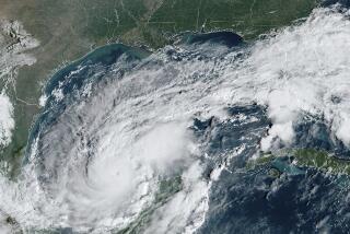
Tropical Storm Isaac, expected to make landfall Tuesday, could bring powerful winds, heavy rain and a storm surge of 6 to 12 feet, forecasters predict. Michael Lowry, a meteorologist with the storm surge group at the National Hurricane Center in Miami, explained what that could mean for Gulf Coast residents.
What is storm surge?
A lot of people think of it like a tsunami, when actually it’s a slow rise of water over many hours. You’ll start to see the water rise before the storm makes landfall Tuesday.
PHOTOS: Tropical Storm Isaac is now Hurricane Isaac
Is storm surge more common on the Gulf Coast?
The Gulf Coast in generally is more vulnerable to storm surge than, say, the East Coast because the coastal shelf is shallower. That broad shelf allows the storm surge to run up much greater distance and be a higher magnitude.
But storm surge is not just a line along the coast — it doesn’t stop on the beach. With Katrina we saw storm surge 30 to 40 miles inland. We don’t expect to see it that far inland with this storm, but you can expect some inland component.
How will the storm surge you expect to see from Isaac compare to what hit New Orleans after Hurricane Katrina?
We’re careful about comparing this with Katrina; this is a different storm, a different event.
It doesn’t take much. We’ve seen significant storm surge with Tropical Storm Lee and other storms in the past. The surge is difficult to predict -- how far the winds extend from the center of the storm can affect the surge. We’re expecting storm surge to be a significant threat for coastal residents from south central Louisiana all the way through the Mississippi and Alabama coast. We’re talking about 6 feet above ground.
Will the levees in New Orleans be able to handle the level of storm surge you’re predicting?
We cannot predict how the levees will hold with these waters. The hurricane risk-reduction system that is in place was put there to mitigate the risk and protect people. There is no forecast of overtopping, but it’s difficult to predict if the numbers will go up. It’s a very slow-moving system and it could kind of stall over the coast and that could create flooding concerns.
Will New Orleans bear the brunt of the storm surge?
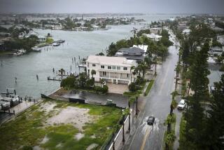
This is not just a New Orleans event. During Tropical Storm Debby, we saw significant storm surge in Tampa and the west coast of Florida, hundreds of miles from the center of the storm.
There are areas to the east that may fall out of the [storm’s] track or the cone. We don’t want those residents to think they won’t also see a significant storm surge hazard.
ALSO:
Sen. Schumer: Capitol dome must be fixed
Military divers deserve own monument, U.S. senator asserts
Maryland school shooting: Heroes overpower gunman; 1 student hurt
More to Read
Sign up for Essential California
The most important California stories and recommendations in your inbox every morning.
You may occasionally receive promotional content from the Los Angeles Times.


