Extreme winds fueled fires and toppled big rigs. But firefighters were prepared for battle

- Share via
At the top of the Ronald Reagan Presidential Library in Simi Valley, the winds were so powerful that people couldn’t stand up straight.
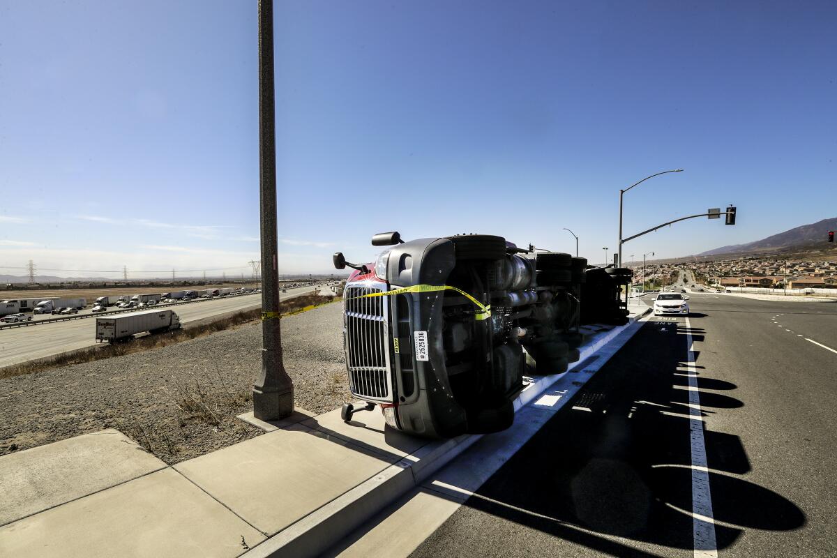
In Fontana, gusts blew over big-rig trucks on the freeway.
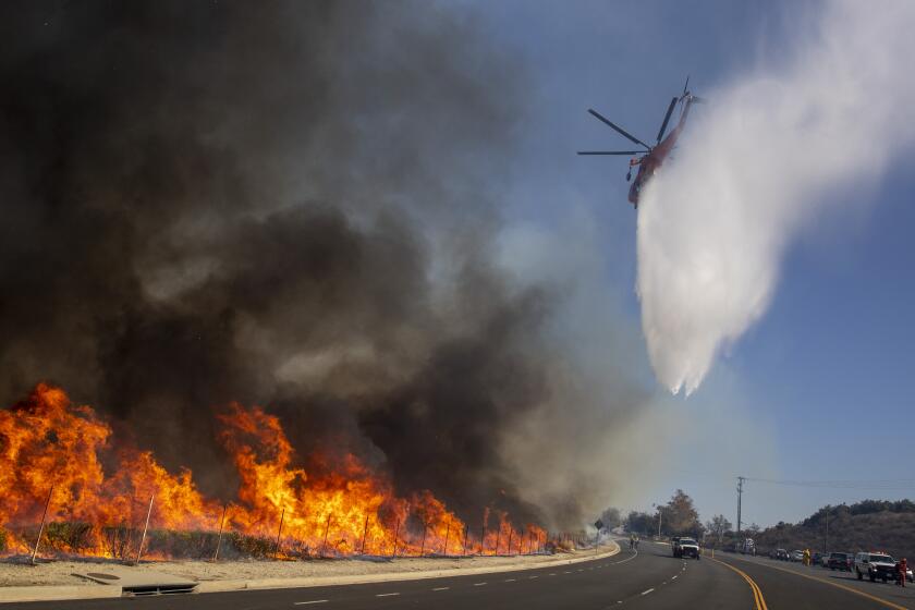
And across Southern California, the Santa Ana winds sprayed embers far and wide, sparking more than a dozen fires from Calabasas to rural Riverside County.
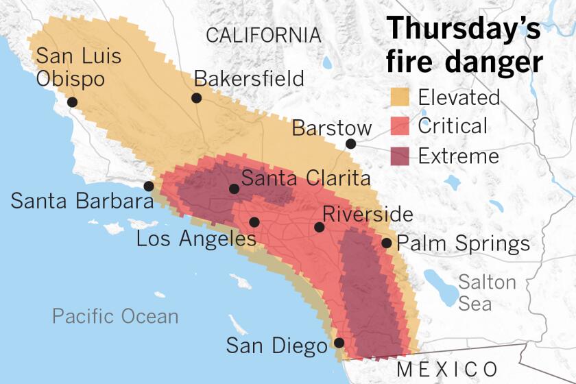
But all the unusual warnings about the strong winds — which prompted an “extreme” fire weather warning that local National Weather Service meteorologists can’t remember making before — gave the region time to prepare.
This time, firefighters credited an intense surge in pre-deployed firefighting resources.
The fight is far from over; the extreme red-flag warning remains in effect through Thursday night, and the Easy fire threatening Ventura County remains out of control. But officials say the preparations for the winds this time have given them a fighting chance that they didn’t have last year, when the Woolsey fire — one of California’s most destructive on record — burned more than 1,000 homes and resulted in three deaths. Officials have said the battle against that fire was hampered by a lack of resources.
Legislation passed in Sacramento, first signed by Gov. Jerry Brown and then made permanent under Gov. Gavin Newsom, has allocated millions of dollars to pre-position firefighting resources during severe fire weather. As a result, on Wednesday, after the weather service’s extreme fire weather warning, a lot more firefighters were prepared to tackle the fire that bounded toward the presidential library, a repository of records and artifacts from the Reagan administration, Ventura County Fire Chief Mark Lorenzen said.
There was ample air support, with helicopters and fixed-wing aircraft repeatedly dropping loads of water nearby. The California Department of Forestry and Fire Protection and the California Office of Emergency Services sent additional trucks, keeping flames from homes and the library. About 800 firefighters fought the Easy fire, which began near Easy Street and Madera Road in Simi Valley shortly after 6 a.m.
“They worked the flanks pretty hard, and then they were incredibly vital when the fire crossed the 23 [Freeway],” Lorenzen said of the air resources. “We had the DC-10 come in and lay down retardant along the 23 and then right in that neighborhood above it, and it gave us the opportunity to get in there and knock it down. In the absence of the aircraft there, that would have been a really big challenge for us to contain that fire.”
This Santa Ana event was forecast to be unusually strong and long-lasting, and weather observations showed how dangerous the conditions were. Gusts of up to 78 mph were recorded on Boney Peak in the Santa Monica Mountains; Camarillo recorded 55 mph.
The air was parched dry, with relative humidity hitting zero atop Mt. Wilson in the San Gabriel Mountains and on peaks in the Santa Ynez Mountains and the Los Padres National Forest, National Weather Service meteorologist Lisa Phillips said.
Vegetation was also extremely dry. Autumn rains have been late in Southern California for each of the last three fall seasons, a big factor in the severe fire weather the region has suffered in recent years.
Drier autumns put California at risk because that’s when Santa Ana winds come sailing out of high-pressure areas in the deserts of Nevada and Utah and target low-pressure voids toward the California coast. As they come down mountain slopes and speed through mountain passes, the intensely dry and fast-moving winds raise the risk of critical fire weather in highly populated areas.
On Wednesday, humidity levels all over Southern California were dry even at lower elevations, with Sinaloa Lake in Simi Valley getting as low as 8% and Moorpark, 7%. Humidity of 15% to 20% is considered quite dry.
The National Weather Service warned that conditions will remain extreme through most of Thursday. The air will continue to be dry, and although Santa Ana winds have probably peaked, they’ll still be strong, expected to gust between 40 mph and 60 mph, said weather service meteorologist Kristen Stewart.
It’s possible that red-flag warnings — a term used to describe critical fire danger because of high winds, low humidity, and dry vegetation — will be extended for valley hills and mountains beyond Thursday afternoon. Thursday night through Friday, top winds will weaken to gusts of 25 mph to 35 mph.
The monster Santa Ana event is being fueled in part by intensely cold high pressure over the Rocky Mountains.
“There’s actually record cold air mass right now over the Rockies and the Great Basin,” said Daniel Swain, climate scientist with UCLA and the National Center for Atmospheric Research. In Boulder, Colo., there’s a foot of snow on the ground and the temperature is 9 degrees — in October.
“This extremely cold air mass directly from the Arctic is sitting just to the east of California. And that is obviously a great contrast with the not-so-frigid air over California, and especially as you get closer to the ocean,” Swain said. “That thermal contrast is setting up that strong pressure contrast, which is in turn driving these very strong winds.”
Temperatures along the California coast are close to average for this time of year, but to the state’s east, they’re well below average — an extreme difference that’s driving the winds, Swain said.
The air mass “dropped straight down southward out of the Arctic over the Rockies because there’s such a big mass of high pressure over Alaska right now, where they have been experiencing record warmth on a recurring basis, and where there is effectively no sea ice on the Arctic Ocean coast for the first time in recorded history in October.”
The warm mass of air over Alaska, as a result, has had the effect of placing “a big blob of cold air over the Rockies, which is creating this extreme contrast that’s generating the winds in California,” Swain said.
Cold Santa Anas can be destructive. The Thomas fire that killed two people and destroyed more than 1,000 structures in Ventura and Santa Barbara counties came during a cool Santa Ana wind event in 2017.
Colder Santa Ana winds can in some ways be more dangerous than warmer Santa Anas, said climatologist Bill Patzert, especially if the high-pressure system behind them is stationary.
Because the air is so cold, it’s also very heavy.
“So it accelerates more rapidly, because it’s so heavy coming through these passes — that’s why you’re getting these extreme wind speeds,” Patzert said.
One way forecasters predict Santa Ana winds is to measure the difference in pressure between Los Angeles International Airport and the community of Daggett in the San Bernardino County desert. The record for October, which sees particularly flammable vegetation if autumn rains haven’t yet arrived, is negative 10.2 millibars, which occurred Oct. 21 and Oct. 22, 2007. On Oct. 21, 2007, a downed San Diego Gas & Electric Co. power line started the Witch fire, which burned nearly 200,000 acres, destroyed more than 1,000 homes, and left two dead.
The forecast pressure difference for this extreme red-flag event was negative 10 millibars. But by Wednesday night, the difference came in short of that, reaching negative 9.3 millibars.
Southern California is expected to get a break from Santa Ana conditions next week, but there is no outlook for rain over the next 10 days.
Weather conditions have improved in Northern California, which has also seen severe fire weather over the last week. Red-flag warnings in the Bay Area expired Wednesday afternoon as winds have eased, although forecasters warned that the air is still quite dry.
More to Read
Sign up for Essential California
The most important California stories and recommendations in your inbox every morning.
You may occasionally receive promotional content from the Los Angeles Times.


