Critical fire danger returns to Southern California this weekend, but showers are possible next week

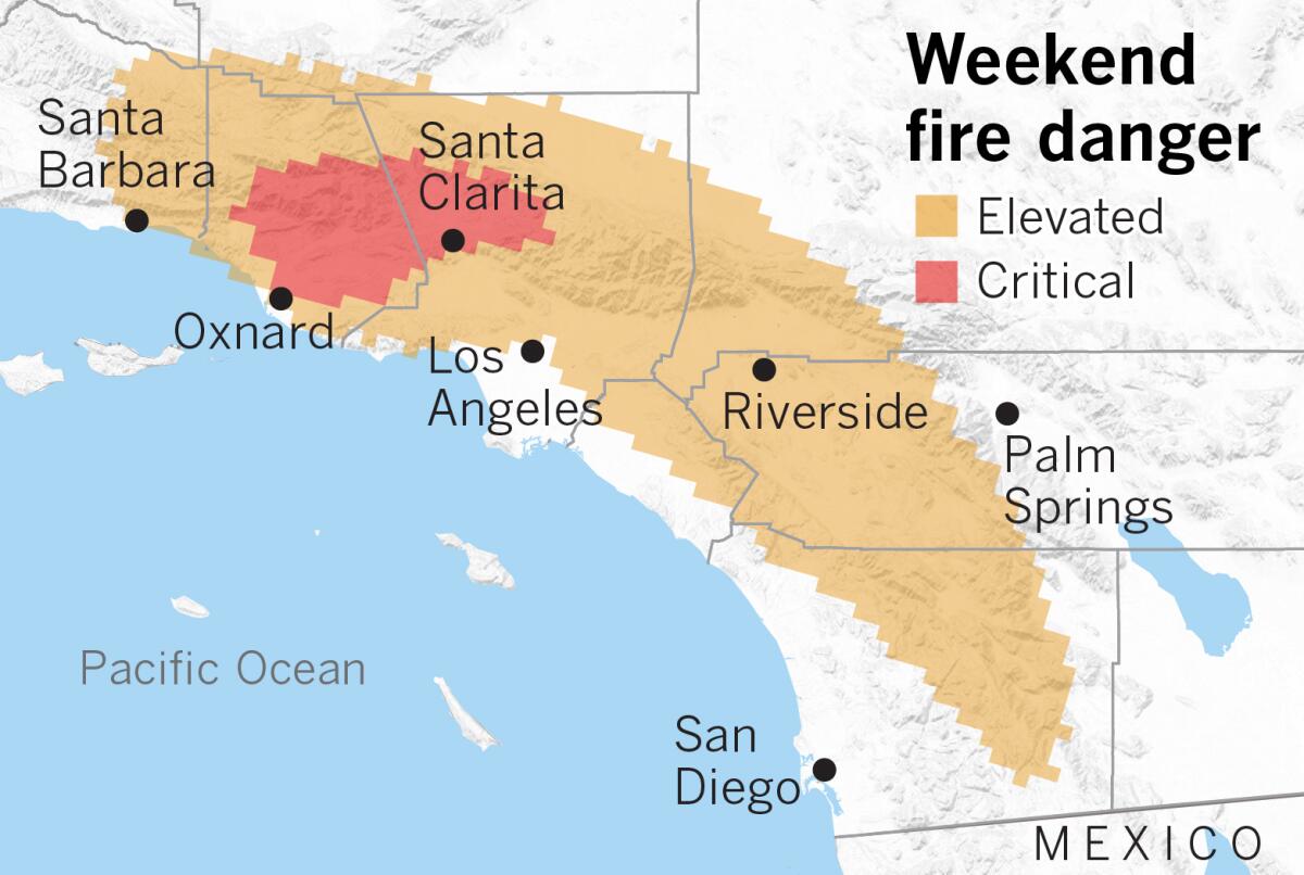
The National Weather Service said that a red flag warning for dangerous fire weather might be issued for Los Angeles and Ventura counties beginning Saturday night, as dry Santa Ana winds return and vegetation remains tinder dry.
Santa Ana winds from the northeast are expected to gust 20 mph to 40 mph in wind-prone areas Saturday as surface high pressure builds in the deserts of Nevada and Utah, where the Great Basin sits, resulting in elevated and critical fire conditions, the National Weather Service’s Storm Prediction Center said.
The National Weather Service office in Oxnard, which manages forecasts for L.A. and Ventura counties, has already issued a fire weather watch in effect from late Saturday night through Sunday afternoon for mountains and some valleys in Ventura and Los Angeles counties.
Meteorologists will decide Saturday whether the fire weather conditions should be upgraded to a red flag warning.
The higher pressure will bring sunny skies and a warming trend this weekend, but models show that the first rain of the season could arrive midweek, followed by a period of cloudy, cool, damp conditions through the end of the week.
The desert-to-sea winds will peak Sunday and will possibly come with a few record high temperatures. The mercury could reach the 80s and low 90s in some coastal and valley areas. Relative humidity may be as low as 8% to 15%, the National Weather Service said.
Critically dry weeds and grasses that grew after the last relatively wet rainfall season, which ended June 30, combined with dead vegetation from years of drought, are of special concern during such weather conditions.
Most of California is either abnormally dry or in moderate drought, according to the U.S. Drought Monitor. All of coastal Southern California is deemed to be abnormally dry, according to the latest data released Thursday.
Winds will diminish Sunday night through Monday, but elevated fire danger will continue.
By Tuesday, sea breezes are expected to return.
Low pressure dropping south along the West Coast on Tuesday will switch the wind pattern and send cooler ocean breezes across Southern California, lowering temperatures by 5 to 10 degrees and increasing clouds from north to south later in the day.
Some locations west of the mountains could see a 30-degree drop in temperatures from Sunday to Wednesday. Downtown Los Angeles, for example, which could be in the low 90s on Sunday, will probably see a high in the low to mid-60s on Wednesday.
The best chance of moisture may arrive Wednesday and linger into Thursday.
More to Read
Sign up for Essential California
The most important California stories and recommendations in your inbox every morning.
You may occasionally receive promotional content from the Los Angeles Times.


