The Big One could leave 250,000-400,000 quake refugees in California. Where will they go?
When a catastrophic earthquake hits California, buildings will topple and potentially hundreds could be killed.
But what gets less attention is the wrenching aftermath of such a huge temblor, which could leave whole neighborhoods torched by fires uninhabitable and hundreds of thousands of people without a home.
Officials are grappling with where all these quake refugees would go.
In the San Francisco Bay Area, more than 400,000 could be displaced in a magnitude 7 earthquake on the Hayward fault, which directly runs underneath cities like Berkeley, Oakland, Hayward and Fremont, said Ken Hudnut, the U.S. Geological Survey’s science advisor for risk reduction. And it’s possible that more than 250,000 people in Southern California could be forced out of their homes after a major earthquake on the San Andreas fault, Hudnut said.
Not everyone will need to stay in public shelters — many will stay with relatives, friends and hotels. Still, more than 175,000 people may have no other choice than stay at a public shelter in Southern California, which could be could be challenged with acute shortages of food, water and medicine, according to ShakeOut, a USGS report simulating a major Southern California earthquake.
And in the Bay Area, so many buildings built under minimal codes could be so damaged many may be forced to move away “for at least several months, and possibly permanently” due to the region’s housing shortage, according to a separate USGS report on a hypothetical Northern California earthquake, called HayWired.
“So many people will be displaced they won’t be able to stay within the metro area,” Keith Porter, a University of Colorado Boulder professor and chief engineer of the USGS earthquake reports, said of a major Bay Area earthquake. “So they’ll move away, just like they moved away from New Orleans after Hurricane Katrina.”
Arizona recently took a major step in dealing with this question. Officials in May launched a full-scale exercise that simulated a mass exodus of 400,000 evacuees from Southern California. The drill gave emergency workers a chance to consider how they would respond to the many elements of the disaster: providing food and shelter, helping unaccompanied minors, assisting in family reunification, and dealing with the transportation and resource hurdles.
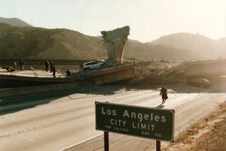
The exercise was aimed at beginning to think about how to deal with such a refugee crisis, though experts in California said it’s unlikely that many people would end up in Arizona. It may actually be quite difficult to leave California after an earthquake moves one side of the San Andreas past the other by as much as 30 feet — severing routes to Phoenix on Interstate 10 in the Coachella Valley and Las Vegas on Interstate 15 at the Cajon Pass.
Also complicating problems would be a widespread lack of power, thwarting the ability of motorists to refuel. “If you choose to go, it’s going to be difficult to do so. It’s a pretty hot desert between you and Phoenix,” seismologist Lucy Jones said.
In the hypothetical magnitude 7.8 earthquake on the San Andreas fault, many people living in eastern L.A. County, Riverside, San Bernardino and the desert cities of the Coachella Valley will likely leave for less affected areas.
But even within Southern California, it’ll be hard to move around. Streets will be clogged with debris; traffic lights won’t work; bridges will be damaged, the USGS says.
Experts said it probably won’t be necessary for quake refugees to go all the way to Arizona or Nevada. Even if a magnitude 7.8 earthquake hits the southern San Andreas, areas farther away from the fault will still be habitable, such as Orange, Ventura and San Diego counties, Jones said.
“There’s going to be a lot of Southern California that’s not going to be devastated,” Jones said.
Which areas are most affected depends on which fault ruptures. A magnitude 7.5 earthquake on the Puente Hills thrust fault directly underneath downtown Los Angeles would be catastrophic there, but would leave Riverside in comparatively better shape.
Experts say it would be much better to shelter in place at home. Owners can take steps to do so by retrofitting older houses or apartments now at risk for sliding off its foundation or collapsing in an earthquake. Residents can prepare by storing water, food, medicine and other supplies to sustain themselves for, ideally, two weeks, or at least a minimum of 72 hours. A gallon of water per day per person is recommended.
Unfortunately, most Californians don’t bother to be prepared, and a failure to stock up on something as basic as drinking water could lead residents to leave even if their home is structurally sound.
“It’s clear the public doesn’t think about these things,” Hudnut said. “I’d rather be one of those people who doesn’t have to go and has more water stored.”
But a big wild card that would push someone to flee are fires following an earthquake, with shattered pipes expected to hamper firefighting.
Most hydrants in the East Bay will be dry in a magnitude 7 earthquake on the Hayward fault, according to an estimate by Charles Scawthorn, a risk consultant to the USGS, helping to allow fires to burn a building floor area equal to 52,000 single-family homes; in Southern California, it’s possible the equivalent of 133,000 single-family homes will be charred.
In three great urban earthquakes in modern history — Lisbon in 1755, San Francisco in 1906 and Tokyo in 1923 — it was the fires following the earthquake that was particularly devastating.
“The fires were overwhelming,” said Jones, author of “The Big Ones: How Natural Disasters Have Shaped Us and What We Can Do About Them.” “If the fire storms are getting going, and we’re going into Santa Ana conditions, and they haven’t been able to control the fires,” it’s possible that people may seek to flee to other states, Jones said.
But states like Arizona could have other problems than just dealing with evacuees. Those states could suffer fuel shortages from the severing of pipelines in California where they cross the San Andreas fault, Jones said.
While California may have to deal with a short-term shelter crisis, a longer-term concern is whether so many people move away permanently that communities wither, jobs are lost and businesses shutter, Jones said.
The only years that L.A. has ever lost population were the two years following the 1971 Sylmar and 1994 Northridge earthquakes, Jones said.
The 3½-day-simulation near Phoenix — planned over the course of a year, involving 75 agencies and more than 1,000 people — first focused on Arizona counties closest to California’s border.
“They will be the first to experience fuel or food shortages, cellphones getting overloaded and a medical surge,” said Judy Kioski, spokeswoman for the Arizona Department of Emergency and Military Affairs. “We’re worried about where are people going to shelter, how do we feed them, and family reunification.”
The exercise included mass of tents on a field near Phoenix simulating a shelter; some acted as evacuees, others practiced how to render aid.
Some lessons have been already learned. “One of the things we identified was turning rest areas into locations where we could have additional information, and providing hard copies of information if cellphones go out,” Kioski said.
Previous drills have taken place in Utah, where the Wasatch fault zone threatens the Salt Lake City area with earthquakes as large as magnitude 7.5, and Missouri, where the New Madrid Seismic Zone generated several earthquakes between magnitudes 7 and 8 in the winter of 1811-12.
In California, officials have undergone their own emergency simulations and drills. Recently, a simulation was held envisioning a big tsunami wiping out roads in Humboldt and Del Norte counties, and officials flew C-130 aircraft and helicopters in an exercise to test how supplies could be flown in and which airports could be accessible, said Kelly Huston, a deputy director for the California Governor’s Office of Emergency Services.
In September, the Bay Area will undergo its annual Urban Shield training that tests the region’s response capabilities in a disaster; this year, the exercise will focus on mass care and sheltering.
Elements of emergency plans have already been put in force. When more than 100,000 people were ordered evacuated downstream of Oroville Dam last year amid fears an emergency spillway could collapse, officials moved to open up mass evacuation centers, including one in Sacramento.
But one lesson that has been learned is that most people aren’t inclined to flee long distances, as was the case in the Wine Country wildfires last year.
“We found most people want to stay near to or close to their homes,” Huston said, even if it meant pitching a tent in front a damaged property. That means a key priority may be, for instance, “to provide food and assistance to neighborhood by neighborhood.”
ron.lin@latimes.com | Twitter: @ronlin
sarah.parvini@latimes.com | Twitter: @sarahparvini
UPDATES:
10:30 a.m., June 4: More information was added about the source of information to estimates published in a USGS report related to fires following earthquakes in the Bay Area and Southern California.
This article was originally published at 6 a.m. on June 3.
More to Read
Sign up for Essential California
The most important California stories and recommendations in your inbox every morning.
You may occasionally receive promotional content from the Los Angeles Times.


